IMAGES TAKEN NEAR TO
School Lane, CANTERBURY, CT3 1BD
Introduction
This page details the photographs taken nearby to School Lane, CT3 1BD by members of the Geograph project.
The Geograph project started in 2005 with the aim of publishing, organising and preserving representative images for every square kilometre of Great Britain, Ireland and the Isle of Man.

There are currently over 7.5m images from over14,400 individuals and you can help contribute to the project by visiting https://www.geograph.org.uk
Image Map
Images are licensed for reuse under creativecommons.org/licenses/by-sa/2.0
Notes
- Clicking on the map will re-center to the selected point.
- The higher the marker number, the further away the image location is from the centre of the postcode.
Image Listing (192 Images Found)
Images are licensed for reuse under creativecommons.org/licenses/by-sa/2.0
Image
Details
Distance
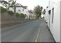
1

Wingham Village Hall
At the end of School Lane.
Image: © David Anstiss
Taken: 15 Aug 2010
0.03 miles
2
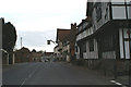
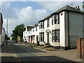
The A257 through Wingham
The Old Canonry on the right is dated 1286.
Image: © David Long
Taken: 20 Apr 2006
0.03 miles
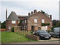
3

Wingham Oast House
As seen from School Lane, near the Village Hall.
Image: © David Anstiss
Taken: 15 Aug 2010
0.03 miles
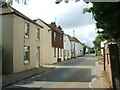
4
Folly Cottage, 14, High Street
Scaffolding had been erected on the frontage of the house, while inside extensive building work was being untaken.
Image: © John Baker
Taken: 20 Aug 2014
0.04 miles
8
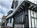
Old Canonry & Canon Cottages
Side view of Dragon beam support and front stained glass windows of Grade 1 listed Wealden Hall construction in Wingham, Kent.
Image: © Kevin Coenemans
Taken: 31 Aug 2019
0.05 miles
9
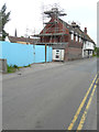
Red Lion, Canterbury Road
Viewed from the B2046, planning permission was granted, with conditions, by Dover District Council under application number DOV/15/00292 for “change of use and conversion to two dwellings (1x5 bed and 1x4 bed), works to create car parking and erection of boundary treatment, including the demolition of existing lean-to, toilet block and outbuilding (amended description and details and additional information)”.
Further scaffolding has been erected on this side of the Image and there are signs that a building is under construction beyond the hoarding.
Image: © John Baker
Taken: 10 Jun 2018
0.05 miles
10
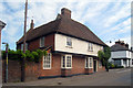
24 High Street, Wingham, Kent
Grade II listed.
Image: © Oast House Archive
Taken: 4 Jul 2009
0.05 miles