IMAGES TAKEN NEAR TO
Park Farm Close, CANTERBURY, CT2 9NR
Introduction
This page details the photographs taken nearby to Park Farm Close, CT2 9NR by members of the Geograph project.
The Geograph project started in 2005 with the aim of publishing, organising and preserving representative images for every square kilometre of Great Britain, Ireland and the Isle of Man.

There are currently over 7.5m images from over14,400 individuals and you can help contribute to the project by visiting https://www.geograph.org.uk
Image Map
Images are licensed for reuse under creativecommons.org/licenses/by-sa/2.0
Notes
- Clicking on the map will re-center to the selected point.
- The higher the marker number, the further away the image location is from the centre of the postcode.
Image Listing (67 Images Found)
Images are licensed for reuse under creativecommons.org/licenses/by-sa/2.0
Image
Details
Distance
1
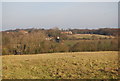
Looking towards Tyler Hill from the track to Little Hall Farm
Image: © N Chadwick
Taken: 31 Jan 2009
0.00 miles
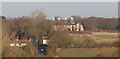
2
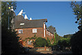
Oast House on Park Farm Close, Tyler Hill, Kent
Four square kilned oast house.
Image: © Oast House Archive
Taken: 22 Sep 2009
0.01 miles
3
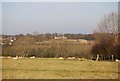
Oast House, Tyler Hill, across the valley
Image: © N Chadwick
Taken: 31 Jan 2009
0.02 miles

5
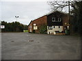
Tyler Hill community centre
On Summer Lane, Tyler Hill
Image: © Nick Smith
Taken: 30 Mar 2008
0.03 miles
6

Footpath across the playing fields, Tyler Hill
Image: © Nick Smith
Taken: 30 Mar 2008
0.03 miles
7

Looking S along Summer Lane
Tyler Hill community centre is on the left of the photo.
Image: © Nick Smith
Taken: 30 Mar 2008
0.03 miles
8

Community centre, Tyler Hill
Set in the corner of a playing field on Summer Lane
Image: © Nick Smith
Taken: 30 Mar 2008
0.03 miles
9
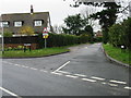
Summer Lane off Hackington Road, Tyler Hill
Image: © Nick Smith
Taken: 30 Mar 2008
0.04 miles
10
Oast house, Park Farm Close, Tyler Hill
A 4 kiln square oast
Image: © N Chadwick
Taken: 31 Jan 2009
0.05 miles