IMAGES TAKEN NEAR TO
Dawes Road, CANTERBURY, CT2 9LF
Introduction
This page details the photographs taken nearby to Dawes Road, CT2 9LF by members of the Geograph project.
The Geograph project started in 2005 with the aim of publishing, organising and preserving representative images for every square kilometre of Great Britain, Ireland and the Isle of Man.

There are currently over 7.5m images from over14,400 individuals and you can help contribute to the project by visiting https://www.geograph.org.uk
Image Map
Images are licensed for reuse under creativecommons.org/licenses/by-sa/2.0
Notes
- Clicking on the map will re-center to the selected point.
- The higher the marker number, the further away the image location is from the centre of the postcode.
Image Listing (19 Images Found)
Images are licensed for reuse under creativecommons.org/licenses/by-sa/2.0
Image
Details
Distance
1
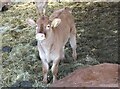
A calf in Holly Hill Farm, Dargate
At first shy, then curious. One of many under cover in a barn.
Image: © pam fray
Taken: 25 Mar 2021
0.00 miles
2
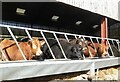
Cattle in Holly Hill Farm, Dargate
Enjoying the food and sunshine.
Image: © pam fray
Taken: 25 Mar 2021
0.01 miles
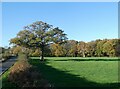
3
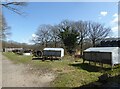
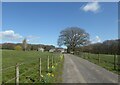
Holly Hill Farm, Dargate
On the track known as Red Road.
Image: © pam fray
Taken: 25 Mar 2021
0.02 miles
4
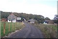
Holly Hill Farm
On Red Road, a bridleway track to Blean Wood (in the background).
Image: © David Anstiss
Taken: 25 Oct 2009
0.03 miles
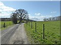
5
Holly Hill Farm, Dargate
Red Road is the track leading to the farm and beyond.
Image: © pam fray
Taken: 25 Mar 2021
0.05 miles
7
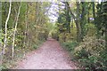
Bridleway heading into Blean Wood
This bridleway leads from Holly Hill Farm to Butler's Hill,Dargate.
Image: © David Anstiss
Taken: 25 Oct 2009
0.13 miles
8
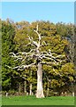
Dead tree, Dawes Road
Near Holly Hill Farm, Denstroude.
Image: © pam fray
Taken: 25 Nov 2022
0.15 miles
9
Living tree and dead tree, Dawes Road
Near Holly Hill Farm, Denstroude.
Image: © pam fray
Taken: 25 Nov 2022
0.17 miles
10
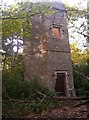
Tower on Holly Hill
This folly is located deep in the forest. It was (apparently) built in the 1930's by a local land owner, to observe ships out at sea. It was abandoned and has since begun to fall apart and being overgrown.
Image: © pray4mojo
Taken: 10 Nov 2006
0.17 miles