IMAGES TAKEN NEAR TO
Mount Pleasant, CANTERBURY, CT2 9EU
Introduction
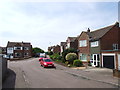
This page details the photographs taken nearby to Mount Pleasant, CT2 9EU by members of the Geograph project.
The Geograph project started in 2005 with the aim of publishing, organising and preserving representative images for every square kilometre of Great Britain, Ireland and the Isle of Man.

There are currently over 7.5m images from over14,400 individuals and you can help contribute to the project by visiting https://www.geograph.org.uk
Image Map
Images are licensed for reuse under creativecommons.org/licenses/by-sa/2.0
Notes
- Clicking on the map will re-center to the selected point.
- The higher the marker number, the further away the image location is from the centre of the postcode.
Image Listing (19 Images Found)
Images are licensed for reuse under creativecommons.org/licenses/by-sa/2.0
Image
Details
Distance
4
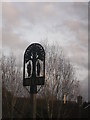
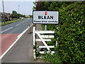
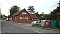
Blean Village Sign
On a small green at the junction of Blean Common Road and Tyler Hill Road.
Image: © David Anstiss
Taken: 21 Jan 2012
0.08 miles
5
Blean Post Office
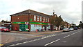
A parade of shops which includes a convenience store and post office, in Blean near Canterbury.
Image: © Malc McDonald
Taken: 26 Oct 2013
0.10 miles
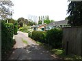
7
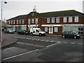
Blean Village Hall
The village hall in Blean, near Canterbury.
Image: © Malc McDonald
Taken: 26 Oct 2013
0.13 miles
10
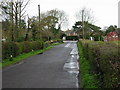
View E along road from Blean to Tyler Hill
Image: © Nick Smith
Taken: 30 Mar 2008
0.16 miles