IMAGES TAKEN NEAR TO
Blean Hill, CANTERBURY, CT2 9EF
Introduction
This page details the photographs taken nearby to Blean Hill, CT2 9EF by members of the Geograph project.
The Geograph project started in 2005 with the aim of publishing, organising and preserving representative images for every square kilometre of Great Britain, Ireland and the Isle of Man.

There are currently over 7.5m images from over14,400 individuals and you can help contribute to the project by visiting https://www.geograph.org.uk
Image Map (Loading...)


Getting Data...Please wait
Leaflet Map data © OpenStreetMap
Images are licensed for reuse under creativecommons.org/licenses/by-sa/2.0
Notes
- Clicking on the map will re-center to the selected point.
- The higher the marker number, the further away the image location is from the centre of the postcode.
Image Listing (21 Images Found)
Images are licensed for reuse under creativecommons.org/licenses/by-sa/2.0
Image
Details
Distance
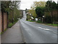
5
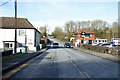
A290 past the Blean Tavern
Heading towards Whitstable.
Image: © Robin Webster
Taken: 8 Feb 2018
0.14 miles
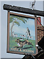
8
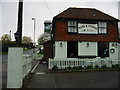
The Hare and Hounds, Blean
An excellent village pub with predominantly Shepherd Neame beers. I have to commend the food; though the menu didn't look very original, the execution was superb.
Image: © Bill Boaden
Taken: 29 Jun 2012
0.16 miles
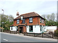
9
The Hare and Hounds on the A290 Canterbury Whitstable road
Image: © Nick Smith
Taken: 30 Mar 2008
0.17 miles
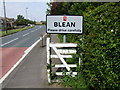
10
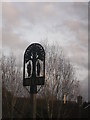
Blean Village Sign
On a small green at the junction of Blean Common Road and Tyler Hill Road.
Image: © David Anstiss
Taken: 21 Jan 2012
0.20 miles