IMAGES TAKEN NEAR TO
Rough Common Road, CANTERBURY, CT2 9DA
Introduction
This page details the photographs taken nearby to Rough Common Road, CT2 9DA by members of the Geograph project.
The Geograph project started in 2005 with the aim of publishing, organising and preserving representative images for every square kilometre of Great Britain, Ireland and the Isle of Man.

There are currently over 7.5m images from over14,400 individuals and you can help contribute to the project by visiting https://www.geograph.org.uk
Image Map
Images are licensed for reuse under creativecommons.org/licenses/by-sa/2.0
Notes
- Clicking on the map will re-center to the selected point.
- The higher the marker number, the further away the image location is from the centre of the postcode.
Image Listing (28 Images Found)
Images are licensed for reuse under creativecommons.org/licenses/by-sa/2.0
Image
Details
Distance
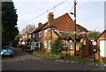
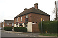
1

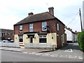
The Dog, Rough Common
Traditional local pub frequented by locals. The Doom Bar struck me as lacking body, but that probably related to the lack of sparkler.
Image: © Bill Boaden
Taken: 24 Jun 2012
0.04 miles
3
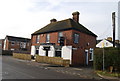
The Dog @ Rough Common
Roadside pub in Rough Common
Image: © N Chadwick
Taken: 24 Jan 2009
0.04 miles
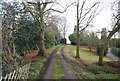
5
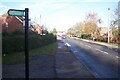
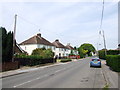
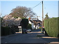
Rough Common Road
This road leads from Palmers Cross Hill to the A290 Whitstable Road. The footpath on the left leads through Stock Wood to Wingate Hill.
Image: © David Anstiss
Taken: 15 Nov 2009
0.09 miles