IMAGES TAKEN NEAR TO
Upper Harbledown, CANTERBURY, CT2 9AY
Introduction
This page details the photographs taken nearby to CT2 9AY by members of the Geograph project.
The Geograph project started in 2005 with the aim of publishing, organising and preserving representative images for every square kilometre of Great Britain, Ireland and the Isle of Man.

There are currently over 7.5m images from over14,400 individuals and you can help contribute to the project by visiting https://www.geograph.org.uk
Image Map
Images are licensed for reuse under creativecommons.org/licenses/by-sa/2.0
Notes
- Clicking on the map will re-center to the selected point.
- The higher the marker number, the further away the image location is from the centre of the postcode.
Image Listing (21 Images Found)
Images are licensed for reuse under creativecommons.org/licenses/by-sa/2.0
Image
Details
Distance
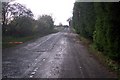
1
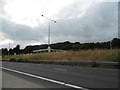
Old London Road, Upper Harbledown
The A2 dual carriageway built in the 1970s can be seen on the left of the picture.
Image: © Chris Whippet
Taken: 24 Nov 2013
0.04 miles
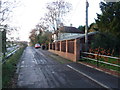
2
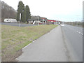
Access road beside the A2 Dual Carriageway
This short length of road leads from the A2 to several houses and farms (on the right) and then joins Roman Road heading towards Upper Harbledown.
Image: © David Anstiss
Taken: 15 Nov 2009
0.07 miles
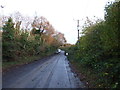
3

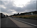
A2 near Upper Harbledown
To the right is the dual carriageway constructed in the 1970s whilst on the left is the old A2.
Image: © Chris Whippet
Taken: 24 Nov 2013
0.09 miles
5

Harbledown Holiday Inn Express
Motel on the A2 Dual Carriageway outside of Canterbury.
See http://www.expressbyholidayinncanterbury.com/ for more details.
Willows wood is in the background.
Image: © David Anstiss
Taken: 15 Nov 2009
0.14 miles
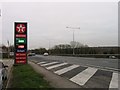
7

Motel on the A2
This site on the North side of the A2 between Boughton and Upper Harbledown consists of a roadside eatery (formerly a Little Chef) a filling station and a Motel. On the left is the southern edge of the large woodland which covers about five square kilometres. At this point it seems to be called Church Wood.
Image: © Penny Mayes
Taken: 21 Apr 2007
0.14 miles
9
Derelict building beside the A2
There was a Pearson Gore estate agent’s board attached to the building that indicated that it had been sold, subject to contract. I looked through all the commercial buildings on the estate agent’s website but I could not find reference to this site. Therefore, I am grateful to David Anstiss for photographing Image, as it confirms what the business used to be.
Image: © John Baker
Taken: 11 Jan 2015
0.16 miles