IMAGES TAKEN NEAR TO
Ryde Street, CANTERBURY, CT2 8QP
Introduction
This page details the photographs taken nearby to Ryde Street, CT2 8QP by members of the Geograph project.
The Geograph project started in 2005 with the aim of publishing, organising and preserving representative images for every square kilometre of Great Britain, Ireland and the Isle of Man.

There are currently over 7.5m images from over14,400 individuals and you can help contribute to the project by visiting https://www.geograph.org.uk
Image Map
Images are licensed for reuse under creativecommons.org/licenses/by-sa/2.0
Notes
- Clicking on the map will re-center to the selected point.
- The higher the marker number, the further away the image location is from the centre of the postcode.
Image Listing (715 Images Found)
Images are licensed for reuse under creativecommons.org/licenses/by-sa/2.0
Image
Details
Distance
2
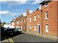
![Canterbury houses [44]](https://s2.geograph.org.uk/geophotos/07/08/31/7083162_caa6f8d5_120x120.jpg)
Canterbury houses [44]
Numbers 11 to 18 Cross Street are a terrace of eight houses built in the early 19th century. Constructed of red brick under a slate roof. Listed, grade II, with details at: https://historicengland.org.uk/listing/the-list/list-entry/1336815
Canterbury is a small historic city on the River Stour in Kent, some 54 miles southeast of London. Occupied since prehistoric times, it became an important Roman city. In 672, the see of Canterbury gained authority over the entire English Church. After the murder of Archbishop Thomas Becket at the cathedral in 1170, pilgrims from all parts of Christendom came to visit his shrine until the Dissolution. Today, Canterbury is a popular tourist destination and one of the most-visited cities in the United Kingdom. The city has a substantial student population, with four university campuses.
Image: © Michael Dibb
Taken: 5 Sep 2021
0.02 miles
3
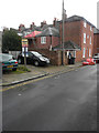
The back of 12, Cross Street
Planning permission has been granted by Canterbury City Council under application number CA//17/00562 for “proposed two-storey rear extension following demolition of existing single-storey rear extension”. The extension is under construction.
This image shows Image after the two-storey extension had been completed.
Image: © John Baker
Taken: 4 Feb 2018
0.03 miles
4
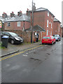
The back of 12, Cross Street
This image shows Image when a two-storey extension was under construction.
Image: © John Baker
Taken: 29 Apr 2018
0.03 miles

7
![Canterbury houses [41]](https://s3.geograph.org.uk/geophotos/07/08/25/7082567_939e2def_120x120.jpg)
Canterbury houses [41]
Number 17 New Street is the end building of the terrace in Cross Street. Built in the early 19th century of red brick under a slate roof. Listed, grade II, with details at: https://historicengland.org.uk/listing/the-list/list-entry/1096941
Canterbury is a small historic city on the River Stour in Kent, some 54 miles southeast of London. Occupied since prehistoric times, it became an important Roman city. In 672, the see of Canterbury gained authority over the entire English Church. After the murder of Archbishop Thomas Becket at the cathedral in 1170, pilgrims from all parts of Christendom came to visit his shrine until the Dissolution. Today, Canterbury is a popular tourist destination and one of the most-visited cities in the United Kingdom. The city has a substantial student population, with four university campuses.
Image: © Michael Dibb
Taken: 5 Sep 2021
0.03 miles
10

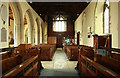
St Dunstan, Canterbury - Stained glass window
Image: © John Salmon
Taken: 31 Mar 2011
0.03 miles