IMAGES TAKEN NEAR TO
City View, CANTERBURY, CT2 8PT
Introduction
This page details the photographs taken nearby to City View, CT2 8PT by members of the Geograph project.
The Geograph project started in 2005 with the aim of publishing, organising and preserving representative images for every square kilometre of Great Britain, Ireland and the Isle of Man.

There are currently over 7.5m images from over14,400 individuals and you can help contribute to the project by visiting https://www.geograph.org.uk
Image Map
Images are licensed for reuse under creativecommons.org/licenses/by-sa/2.0
Notes
- Clicking on the map will re-center to the selected point.
- The higher the marker number, the further away the image location is from the centre of the postcode.
Image Listing (52 Images Found)
Images are licensed for reuse under creativecommons.org/licenses/by-sa/2.0
Image
Details
Distance
1
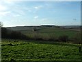
Golden Hill
The view from the National Trust owned 'Golden Hill'
Image: © Ben Charlton
Taken: 18 Jan 2004
0.06 miles
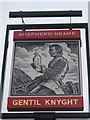
2
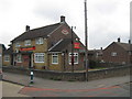
The Gentil Knight Pub Canterbury
In a housing estate near Harbledown.
On the junction of Shipman Avenue (on the left) and Knight Avenue (on the right).
Image: © David Anstiss
Taken: 15 Aug 2010
0.08 miles
4
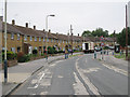
Knight Avenue
A curved road of semi-detached houses.
Image: © Oast House Archive
Taken: 20 Jul 2010
0.16 miles
5
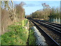
The line to Canterbury West seen from Whitehall Road crossing
The South Eastern Railway began its services from Ashford to what is now Canterbury West on 6th February 1846 and the line was extended to Ramsgate two months later. The green bridge ahead carries the line between Faversham and Canterbury East which was opened on 9th July 1860 by the London, Chatham & Dover Railway.
This view is from the Stour Valley Walk which here follows Whitehall Road and crosses the line via pedestrian gate's although vehicles are able to open the full gates. This looks in the direction of Canterbury West.
Image: © Marathon
Taken: 14 Dec 2013
0.16 miles
7
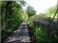
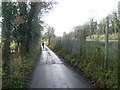
Small lane leading to Whitehall Farm
The lane runs parallel to the railway before crossing it a few hundred metres further on.
Image: © Nick Smith
Taken: 26 Apr 2008
0.17 miles
8
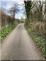
Whitehall Lane: former level crossing
This is the site of the former level crossing at Harbledown Junction, across Whitehall Lane, taken by the Elham Valley Light Railway. The crossing was immediately after leaving the main line. In order to reduce inconvenience, the railway company was required to provide a tunnel with low headroom under the railway immediately to the south, which still can be identified by passing through a nearby stile.
Image: © Hugh Craddock
Taken: 8 Apr 2021
0.17 miles
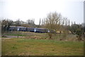
9
Whitehall Road alongside the railway line
Whitehall Road is followed here by the Stour Valley Walk. The railway line on the right is between Chartham and Canterbury West which here follows Whitehall Road until a level crossing is reached just ahead.
The South Eastern Railway began its services from Ashford to what is now Canterbury West on 6th February 1846 and the line was extended to Ramsgate two months later. Until 1947 the Elham Valley Line came in on the left to meet the Canterbury West line. The Elham Valley Line opened in 1887 and closed to passengers in 1940, closing completely in 1947. All the information about the Elham Valley Railway is given here http://www.disused-stations.org.uk/e/elham/index.shtml
Image: © Marathon
Taken: 14 Dec 2013
0.17 miles
