IMAGES TAKEN NEAR TO
Wife Of Bath Hill, CANTERBURY, CT2 8PQ
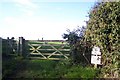
Introduction
This page details the photographs taken nearby to Wife Of Bath Hill, CT2 8PQ by members of the Geograph project.
The Geograph project started in 2005 with the aim of publishing, organising and preserving representative images for every square kilometre of Great Britain, Ireland and the Isle of Man.

There are currently over 7.5m images from over14,400 individuals and you can help contribute to the project by visiting https://www.geograph.org.uk
Image Map
Images are licensed for reuse under creativecommons.org/licenses/by-sa/2.0
Notes
- Clicking on the map will re-center to the selected point.
- The higher the marker number, the further away the image location is from the centre of the postcode.
Image Listing (25 Images Found)
Images are licensed for reuse under creativecommons.org/licenses/by-sa/2.0
Image
Details
Distance
1
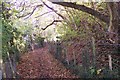
North Downs Way on Golden Hill
The path heads up an ancient trackway towards Harbledown.
Image: © David Anstiss
Taken: 15 Nov 2009
0.04 miles
2
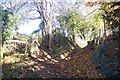
Footpath junction on Golden Hill
The North Downs Way follows an ancient trackway towards Harbledown. The stile on the left is an entrance to the National Trust owned open land of Golden Hill.
Image: © David Anstiss
Taken: 15 Nov 2009
0.05 miles
3
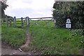
Footpath onto Golden Hill, Harbledown
Path crossing the hill, a National Trust property.
Image: © Jim Barton
Taken: 24 Sep 2015
0.06 miles
4
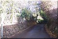
The North Downs Way meets Mill Lane
The path heads from Golden Hill into Harbledown.
Image: © David Anstiss
Taken: 15 Nov 2009
0.07 miles
5
Golden Hill, Harbledown
Small area of grassland near Mill Lane. Has good views.
See http://www.harbledownpc.kentparishes.gov.uk/default.cfm?pid=1087 for more details.
Image: © David Anstiss
Taken: 15 Nov 2009
0.07 miles
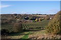
6
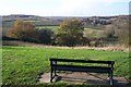
View from the Bench on Golden Hill
Looking North-westerly over the Harbledown Orchards.
Golden Hill is a small grassland owned and managed by the National Trust.
See http://www.harbledownpc.kentparishes.gov.uk/default.cfm?pid=1087 for more details.
Image: © David Anstiss
Taken: 15 Nov 2009
0.08 miles
7
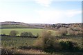
View westerly from Golden Hill
Looking across the Orchards of Harbledown. Looking from the National Trust grassland near Mill Lane.
Image: © David Anstiss
Taken: 15 Nov 2009
0.13 miles
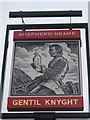
9
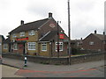
The Gentil Knight Pub Canterbury
In a housing estate near Harbledown.
On the junction of Shipman Avenue (on the left) and Knight Avenue (on the right).
Image: © David Anstiss
Taken: 15 Aug 2010
0.14 miles
10
View of Hospital Farm from Golden Hill
Seen from a National Trust owned grassland near Mill Lane. Rough Common is in the background (in the middle) with Stock Wood on the left.
Image: © David Anstiss
Taken: 15 Nov 2009
0.14 miles