IMAGES TAKEN NEAR TO
St. Dunstans Close, CANTERBURY, CT2 8LP
Introduction
This page details the photographs taken nearby to St. Dunstans Close, CT2 8LP by members of the Geograph project.
The Geograph project started in 2005 with the aim of publishing, organising and preserving representative images for every square kilometre of Great Britain, Ireland and the Isle of Man.

There are currently over 7.5m images from over14,400 individuals and you can help contribute to the project by visiting https://www.geograph.org.uk
Image Map
Images are licensed for reuse under creativecommons.org/licenses/by-sa/2.0
Notes
- Clicking on the map will re-center to the selected point.
- The higher the marker number, the further away the image location is from the centre of the postcode.
Image Listing (314 Images Found)
Images are licensed for reuse under creativecommons.org/licenses/by-sa/2.0
Image
Details
Distance
1
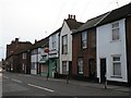
Canterbury: St. Dunstan?s Post Office
One of 56 post office branches in Kent that are closing during January 2008 – the last day of business for this one was the 10th.
Image: © Chris Downer
Taken: 5 Jan 2008
0.03 miles
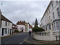
2
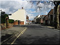
Looking NE along London Road, Canterbury
The Eight Bells pub is the white building on the left
Image: © Nick Smith
Taken: 8 Apr 2008
0.04 miles
3
![Canterbury houses [21]](https://s2.geograph.org.uk/geophotos/07/08/16/7081634_8b2463ff_120x120.jpg)
Canterbury houses [21]
Number 15 London Road was built in the early 19th century. Constructed of stuccoed brick under a tile roof. Listed, grade II, with details at: https://historicengland.org.uk/listing/the-list/list-entry/1079091
Canterbury is a small historic city on the River Stour in Kent, some 54 miles southeast of London. Occupied since prehistoric times, it became an important Roman city. In 672, the see of Canterbury gained authority over the entire English Church. After the murder of Archbishop Thomas Becket at the cathedral in 1170, pilgrims from all parts of Christendom came to visit his shrine until the Dissolution. Today, Canterbury is a popular tourist destination and one of the most-visited cities in the United Kingdom. The city has a substantial student population, with four university campuses.
Image: © Michael Dibb
Taken: 5 Sep 2021
0.04 miles
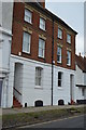
5
![Canterbury houses [20]](https://s1.geograph.org.uk/geophotos/07/08/16/7081633_e921239a_120x120.jpg)
Canterbury houses [20]
Numbers 13 and 14 London Road are a pair of late 18th century houses. Constructed in two parallel ranges of brick, red to the sides, buff to the front, all under a tile roof. Listed, grade II, with details at: https://historicengland.org.uk/listing/the-list/list-entry/1079090
Canterbury is a small historic city on the River Stour in Kent, some 54 miles southeast of London. Occupied since prehistoric times, it became an important Roman city. In 672, the see of Canterbury gained authority over the entire English Church. After the murder of Archbishop Thomas Becket at the cathedral in 1170, pilgrims from all parts of Christendom came to visit his shrine until the Dissolution. Today, Canterbury is a popular tourist destination and one of the most-visited cities in the United Kingdom. The city has a substantial student population, with four university campuses.
Image: © Michael Dibb
Taken: 5 Sep 2021
0.04 miles
6
![Canterbury houses [19]](https://s0.geograph.org.uk/geophotos/07/08/16/7081632_9d1a78de_120x120.jpg)
Canterbury houses [19]
Number 12 London Road was built in the mid 19th century. Constructed of stuccoed brick under a tile roof. Listed, grade II, with details at: https://historicengland.org.uk/listing/the-list/list-entry/1260733
Canterbury is a small historic city on the River Stour in Kent, some 54 miles southeast of London. Occupied since prehistoric times, it became an important Roman city. In 672, the see of Canterbury gained authority over the entire English Church. After the murder of Archbishop Thomas Becket at the cathedral in 1170, pilgrims from all parts of Christendom came to visit his shrine until the Dissolution. Today, Canterbury is a popular tourist destination and one of the most-visited cities in the United Kingdom. The city has a substantial student population, with four university campuses.
Image: © Michael Dibb
Taken: 5 Sep 2021
0.04 miles
7
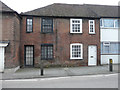
13 & 15, Whitstable Road
Number 13, on the left, appears uninhabited.
Image: © John Baker
Taken: 27 Dec 2015
0.04 miles
8
![Canterbury houses [18]](https://s3.geograph.org.uk/geophotos/07/08/16/7081631_322f05d6_120x120.jpg)
Canterbury houses [18]
Numbers 10 and 11 London Road are a pair of 18th century houses, refronted in the 19th century. Constructed in two parallel ranges of red brick with a stuccoed, rusticated ground floor, all under a tile roof. Listed, grade II, with details at: https://historicengland.org.uk/listing/the-list/list-entry/1079089
Canterbury is a small historic city on the River Stour in Kent, some 54 miles southeast of London. Occupied since prehistoric times, it became an important Roman city. In 672, the see of Canterbury gained authority over the entire English Church. After the murder of Archbishop Thomas Becket at the cathedral in 1170, pilgrims from all parts of Christendom came to visit his shrine until the Dissolution. Today, Canterbury is a popular tourist destination and one of the most-visited cities in the United Kingdom. The city has a substantial student population, with four university campuses.
Image: © Michael Dibb
Taken: 5 Sep 2021
0.04 miles
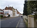
9
London Road, Canterbury
New Street is on the right and St Dunstan's Churchyard is reached just ahead.
Image: © Marathon
Taken: 14 Dec 2013
0.05 miles
10
London Road, Canterbury
St Dunstan's Close is on the left and St Dunstan's Churchyard is reached just ahead.
Image: © Marathon
Taken: 14 Dec 2013
0.05 miles