IMAGES TAKEN NEAR TO
St. Dunstans Street, CANTERBURY, CT2 8BH
Introduction
This page details the photographs taken nearby to St. Dunstans Street, CT2 8BH by members of the Geograph project.
The Geograph project started in 2005 with the aim of publishing, organising and preserving representative images for every square kilometre of Great Britain, Ireland and the Isle of Man.

There are currently over 7.5m images from over14,400 individuals and you can help contribute to the project by visiting https://www.geograph.org.uk
Image Map
Images are licensed for reuse under creativecommons.org/licenses/by-sa/2.0
Notes
- Clicking on the map will re-center to the selected point.
- The higher the marker number, the further away the image location is from the centre of the postcode.
Image Listing (1396 Images Found)
Images are licensed for reuse under creativecommons.org/licenses/by-sa/2.0
Image
Details
Distance
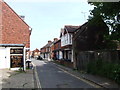
1
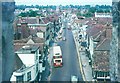
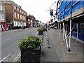
St Dunstan's Street from Westgate Tower 1970
St Dunstan's Street continues as Whitstable Road.
Image: © John Baker
Taken: 14 Jun 1970
0.01 miles
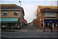
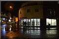
3
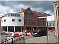
Sainsbury's Local, Canterbury
A modern housing development and small supermarket on the junction of St Dunstan's Street (on the left) and Station Road West (on the right).
Image: © David Anstiss
Taken: 16 Jul 2012
0.01 miles
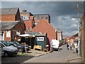
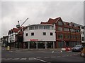
6
New student accommodation on Station Road West
Image: © Oast House Archive
Taken: 20 Apr 2012
0.02 miles