IMAGES TAKEN NEAR TO
Queens Avenue, CANTERBURY, CT2 8AY
Introduction
This page details the photographs taken nearby to Queens Avenue, CT2 8AY by members of the Geograph project.
The Geograph project started in 2005 with the aim of publishing, organising and preserving representative images for every square kilometre of Great Britain, Ireland and the Isle of Man.

There are currently over 7.5m images from over14,400 individuals and you can help contribute to the project by visiting https://www.geograph.org.uk
Image Map
Images are licensed for reuse under creativecommons.org/licenses/by-sa/2.0
Notes
- Clicking on the map will re-center to the selected point.
- The higher the marker number, the further away the image location is from the centre of the postcode.
Image Listing (692 Images Found)
Images are licensed for reuse under creativecommons.org/licenses/by-sa/2.0
Image
Details
Distance
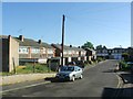
1
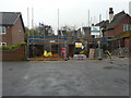
House under construction, Whitehall Bridge Road
Planning permission was granted by Canterbury City Council under application number CA//16/02903 for a “proposed detached two-storey dwelling with parking and integral garage”. The site was previously a parking space for 3, Queens Avenue, which is the house on the right.
Image: © John Baker
Taken: 29 Apr 2018
0.04 miles
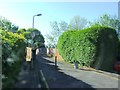
2
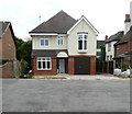
Recently completed house, Whitehall Bridge Road
This was the Image
Image: © John Baker
Taken: 4 Aug 2019
0.04 miles
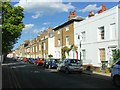
3
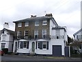
Nos 24 and 25, St Dunstans Terrace
2 Grade II listed buildings on Orchard Street (facing St Dunstans Terrace).
See http://www.britishlistedbuildings.co.uk/en-440489-st-dunston-s-terrace-kent for more details about the buildings.
Image: © David Anstiss
Taken: 17 Feb 2014
0.04 miles
5
![Canterbury houses [37]](https://s3.geograph.org.uk/geophotos/07/08/24/7082499_9024a24b_120x120.jpg)
Canterbury houses [37]
Numbers 24 and 25 Orchard Street were built circa 1830, originally as part of St Dunstan's Terrace. Constructed of red brick with the front in yellow brick, the ground floor stuccoed, all under a slate roof. Listed, grade II, with details at: https://historicengland.org.uk/listing/the-list/list-entry/1260520
Canterbury is a small historic city on the River Stour in Kent, some 54 miles southeast of London. Occupied since prehistoric times, it became an important Roman city. In 672, the see of Canterbury gained authority over the entire English Church. After the murder of Archbishop Thomas Becket at the cathedral in 1170, pilgrims from all parts of Christendom came to visit his shrine until the Dissolution. Today, Canterbury is a popular tourist destination and one of the most-visited cities in the United Kingdom. The city has a substantial student population, with four university campuses.
Image: © Michael Dibb
Taken: 5 Sep 2021
0.04 miles
7
![Canterbury houses [36]](https://s1.geograph.org.uk/geophotos/07/08/24/7082493_3d857a4e_120x120.jpg)
Canterbury houses [36]
Numbers 22 and 23 Orchard Street are a pair of Tudor Gothic villas built circa 1830. Constructed of stuccoed brick under roofs of slate (number 22) and tile (number 23). Listed, grade II, with details at: https://historicengland.org.uk/listing/the-list/list-entry/1260519
Canterbury is a small historic city on the River Stour in Kent, some 54 miles southeast of London. Occupied since prehistoric times, it became an important Roman city. In 672, the see of Canterbury gained authority over the entire English Church. After the murder of Archbishop Thomas Becket at the cathedral in 1170, pilgrims from all parts of Christendom came to visit his shrine until the Dissolution. Today, Canterbury is a popular tourist destination and one of the most-visited cities in the United Kingdom. The city has a substantial student population, with four university campuses.
Image: © Michael Dibb
Taken: 5 Sep 2021
0.04 miles
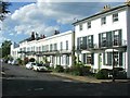
10
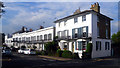
St. Dunstan's Terrace
These beautiful terraces were once on the edge of town.
I imagine the owners were more than a little peeved when the expanding city swamped the view from their balconies.
Compare this side of the street with the one opposite. Image
Hard to believe it's the same road.
Image: © Des Blenkinsopp
Taken: 19 Aug 2011
0.05 miles