IMAGES TAKEN NEAR TO
St. Dunstans Street, CANTERBURY, CT2 8AE
Introduction
This page details the photographs taken nearby to St. Dunstans Street, CT2 8AE by members of the Geograph project.
The Geograph project started in 2005 with the aim of publishing, organising and preserving representative images for every square kilometre of Great Britain, Ireland and the Isle of Man.

There are currently over 7.5m images from over14,400 individuals and you can help contribute to the project by visiting https://www.geograph.org.uk
Image Map
Images are licensed for reuse under creativecommons.org/licenses/by-sa/2.0
Notes
- Clicking on the map will re-center to the selected point.
- The higher the marker number, the further away the image location is from the centre of the postcode.
Image Listing (1553 Images Found)
Images are licensed for reuse under creativecommons.org/licenses/by-sa/2.0
Image
Details
Distance
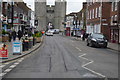
2
St Dunstan's Street
St Dunstan's Street on a bright sunny August day, viewed from West Gate.
Image: © Philip Halling
Taken: 11 Aug 2021
0.00 miles
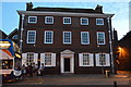
3
![Canterbury buildings [32]](https://s2.geograph.org.uk/geophotos/07/08/49/7084934_e806f5cf_120x120.jpg)
Canterbury buildings [32]
Westgate House, number 88 St Dunstan's Street, is dated 1750. Constructed of red brick under a hipped tile roof. There is a late 19th century extension to the left. Many original internal features remain. Now used as offices. Listed, grade II*, with details at: https://historicengland.org.uk/listing/the-list/list-entry/1241911
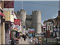
Canterbury is a small historic city on the River Stour in Kent, some 54 miles southeast of London. Occupied since prehistoric times, it became an important Roman city. In 672, the see of Canterbury gained authority over the entire English Church. After the murder of Archbishop Thomas Becket at the cathedral in 1170, pilgrims from all parts of Christendom came to visit his shrine until the Dissolution. Today, Canterbury is a popular tourist destination and one of the most-visited cities in the United Kingdom. The city has a substantial student population, with four university campuses.
Image: © Michael Dibb
Taken: 6 Sep 2021
0.00 miles

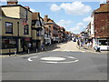
5
St Dunstan's Street
Looking towards West Gate.
Image: © Oast House Archive
Taken: 20 Apr 2012
0.01 miles
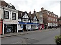
8
Curtain Call, 88, St Dunstan?s Street
The shop, which specialises in made to measure curtains and blinds (also alterations to them) is having a closing down sale.
The posts in the road, behind the yellow line, were installed for the purpose of social distancing, during the coronavirus pandemic.
Image: © John Baker
Taken: 6 Dec 2020
0.01 miles
9
![Canterbury buildings [33]](https://s3.geograph.org.uk/geophotos/07/08/49/7084935_4e5b8841_120x120.jpg)
Canterbury buildings [33]
Number 88 St Dunstan's Street has an early 19th century front to an earlier structure. Timber framed, the front in buff brick, all under an old tile roof. The shopfront is early 19th century. Listed, grade II, with details at: https://historicengland.org.uk/listing/the-list/list-entry/1260294
Canterbury is a small historic city on the River Stour in Kent, some 54 miles southeast of London. Occupied since prehistoric times, it became an important Roman city. In 672, the see of Canterbury gained authority over the entire English Church. After the murder of Archbishop Thomas Becket at the cathedral in 1170, pilgrims from all parts of Christendom came to visit his shrine until the Dissolution. Today, Canterbury is a popular tourist destination and one of the most-visited cities in the United Kingdom. The city has a substantial student population, with four university campuses.
Image: © Michael Dibb
Taken: 6 Sep 2021
0.01 miles
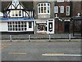
10
Westgate House
Grade II listed. http://www.britishlistedbuildings.co.uk/en-441174-westgate-house-kent
Image: © N Chadwick
Taken: 22 Aug 2015
0.01 miles