IMAGES TAKEN NEAR TO
Hunton Gardens, CANTERBURY, CT2 7TT
Introduction
This page details the photographs taken nearby to Hunton Gardens, CT2 7TT by members of the Geograph project.
The Geograph project started in 2005 with the aim of publishing, organising and preserving representative images for every square kilometre of Great Britain, Ireland and the Isle of Man.

There are currently over 7.5m images from over14,400 individuals and you can help contribute to the project by visiting https://www.geograph.org.uk
Image Map
Images are licensed for reuse under creativecommons.org/licenses/by-sa/2.0
Notes
- Clicking on the map will re-center to the selected point.
- The higher the marker number, the further away the image location is from the centre of the postcode.
Image Listing (17 Images Found)
Images are licensed for reuse under creativecommons.org/licenses/by-sa/2.0
Image
Details
Distance
1
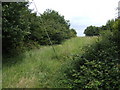
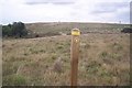
Footpath north to Brickhouse Wood
Just beyond the final urban sprawl of north Canterbury.
Image: © Jonathan Billinger
Taken: 27 Jun 2007
0.08 miles
2
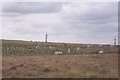
Hissing pipe and Drilling Rig
This former quarry to the South of Shelford Farm. Has been back-filled (presumably with household waste) and boreholes are now being drilled into the site to release the gases built up in the ground.
Image: © David Anstiss
Taken: 30 Sep 2009
0.09 miles
3
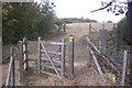
Kissing Gate on Barton Down
This gate is on a footpath from Broad Oak Road to Hunton Gardens, Hale Place.
The route of the path does not match the OS Map due to the work being carried out on the former quarry.
Image: © David Anstiss
Taken: 30 Sep 2009
0.11 miles
6
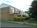
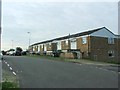
Bawden Close, Hales Place, Canterbury
A 1960's estate on the north side of the city. This countryside Image is 300 yards from this spot.
Image: © Jonathan Billinger
Taken: 27 Jun 2007
0.11 miles
8
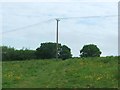
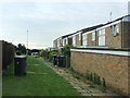
Footpath to Brickhouse Wood
This path leads from Hunton Garden, Hales Place. It should lead straight over Barton Down to Shelford Farm. Due to the backfilling of a quarry in Barton Down the footpath is diverted northwards. The former landfilled quarry is on the right.
Image: © David Anstiss
Taken: 30 Sep 2009
0.13 miles
10
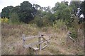
Stile and Gate near Brickhouse Wood
This stile is on a diverted footpath from Hunton Gardens, Hale Place, Canterbury towards Shelford Farm. The path should lead direct to the farm, but it leads through a former quarry, south of the farm. The quarry has now been backfilled with landfill and so the path has been diverted around via the wood.
Image: © David Anstiss
Taken: 30 Sep 2009
0.15 miles