IMAGES TAKEN NEAR TO
CANTERBURY, CT2 7NH
Introduction
This page details the photographs taken nearby to CT2 7NH by members of the Geograph project.
The Geograph project started in 2005 with the aim of publishing, organising and preserving representative images for every square kilometre of Great Britain, Ireland and the Isle of Man.

There are currently over 7.5m images from over14,400 individuals and you can help contribute to the project by visiting https://www.geograph.org.uk
Image Map
Images are licensed for reuse under creativecommons.org/licenses/by-sa/2.0
Notes
- Clicking on the map will re-center to the selected point.
- The higher the marker number, the further away the image location is from the centre of the postcode.
Image Listing (56 Images Found)
Images are licensed for reuse under creativecommons.org/licenses/by-sa/2.0
Image
Details
Distance
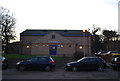
1
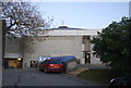
Ingram Building, Park Wood Rd, University of Kent
Image: © N Chadwick
Taken: 24 Jan 2009
0.01 miles
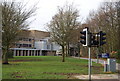
2
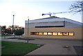
Department of Electronics, University of Kent, Canterbury
The device on the roof is an antenna test tower.
Image: © Penny Mayes
Taken: 21 Apr 2007
0.04 miles
3
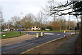
Roundabout at the junction of Park Wood Rd & Giles Lane
Image: © N Chadwick
Taken: 24 Jan 2009
0.08 miles
4
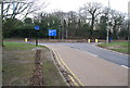
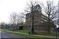
Junction of Park Wood Rd & Giles Lane, University of Kent
Image: © N Chadwick
Taken: 24 Jan 2009
0.08 miles
7
Footpath leading off Park Wood Rd, University of Kent
Image: © N Chadwick
Taken: 24 Jan 2009
0.08 miles
8

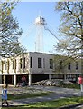
Path and cycleway at the University of Kent
It is decorated in anticipation of the visit of the Olympic torch in a few weeks.
Image: © Bill Boaden
Taken: 24 Jun 2012
0.09 miles