IMAGES TAKEN NEAR TO
Beaconsfield Road, CANTERBURY, CT2 7LG
Introduction
This page details the photographs taken nearby to Beaconsfield Road, CT2 7LG by members of the Geograph project.
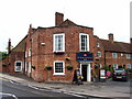
The Geograph project started in 2005 with the aim of publishing, organising and preserving representative images for every square kilometre of Great Britain, Ireland and the Isle of Man.

There are currently over 7.5m images from over14,400 individuals and you can help contribute to the project by visiting https://www.geograph.org.uk
Image Map
Images are licensed for reuse under creativecommons.org/licenses/by-sa/2.0
Notes
- Clicking on the map will re-center to the selected point.
- The higher the marker number, the further away the image location is from the centre of the postcode.
Image Listing (79 Images Found)
Images are licensed for reuse under creativecommons.org/licenses/by-sa/2.0
Image
Details
Distance
1
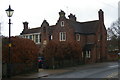
Former St Stephen's School, St Stephen's Green
Image: © Christopher Hilton
Taken: 26 Nov 2018
0.03 miles
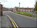
2
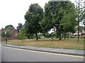
St Stephen's Green just south of its junction with Beaconsfield Road
Image: © Elliott Simpson
Taken: 18 Aug 2011
0.03 miles
3
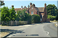
Old St Stephen's School, Canterbury
A grade II listed building built 1848.
Image: © Robin Webster
Taken: 8 Jul 2018
0.03 miles
4
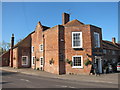
Ye Olde Beverlie
A Shepherd Neame pub on St Stephen's Green at junction with Hales Drive.
Image: © Oast House Archive
Taken: 8 Apr 2011
0.06 miles
6
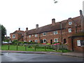
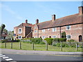
Manwood's Hospital, St. Stephens Green, Canterbury
http://www.britishlistedbuildings.co.uk/en-443291-manwood-s-hospital-kent
Image: © Chris Whippet
Taken: 6 Jul 2014
0.07 miles
7
St Stephen's Green
As on the nameplate; on the right of the green is Hales Drive.
Image: © John Baker
Taken: 24 Nov 2013
0.07 miles
8
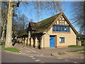
St Stephen's Church Hall
At end of Hales Drive.
Image: © Oast House Archive
Taken: 8 Apr 2011
0.09 miles
9
Ye Olde Beverlie Inne, St. Stephens Green
Viewed from Hales Drive near St. Stephen's Church, Hackington, Canterbury.
Image: © pam fray
Taken: 24 Apr 2009
0.09 miles
10
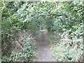
The trackbed of the former Canterbury to Whitstable Railway
The Canterbury to Whitstable Railway (nicknamed The Crab and Winkle) was opened on 3 May 1830 with stations at Canterbury West and Whitstable Harbour only. Three further stations were opened during the 20th century at Blean and Tyler Hill Halt on 13 June 1908, South Street Halt on 1 July 1911 and Tankerton Halt on 1 July 1914. The railway was closed to passengers on 31 December 1930 and to all traffic on 1 December 1952. However, the following year it was reopened from 6-28 February to carry essential services from Canterbury to Whitstable, as a result of the severe coastal flooding that occurred along the east coast of the UK early in 1953.
Image: © John Baker
Taken: 1 Sep 2013
0.09 miles