IMAGES TAKEN NEAR TO
St. Stephens Road, CANTERBURY, CT2 7JE
Introduction
This page details the photographs taken nearby to St. Stephens Road, CT2 7JE by members of the Geograph project.
The Geograph project started in 2005 with the aim of publishing, organising and preserving representative images for every square kilometre of Great Britain, Ireland and the Isle of Man.

There are currently over 7.5m images from over14,400 individuals and you can help contribute to the project by visiting https://www.geograph.org.uk
Image Map (Loading...)


Getting Data...Please wait
Leaflet Map data © OpenStreetMap
Images are licensed for reuse under creativecommons.org/licenses/by-sa/2.0
Notes
- Clicking on the map will re-center to the selected point.
- The higher the marker number, the further away the image location is from the centre of the postcode.
Image Listing (113 Images Found)
Images are licensed for reuse under creativecommons.org/licenses/by-sa/2.0
Image
Details
Distance
1
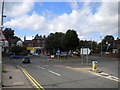
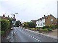
St Stephen's Road roundabout, Canterbury
The roundabout just outside the city centre where St Stephen's Road (left and in the distance) meets Broad Oak Road (out of frame to the right) and Kingsmead Road (foreground). A small parade of shops stands on the west side of the roundabout.
Image: © Richard Vince
Taken: 25 Aug 2012
0.02 miles
3
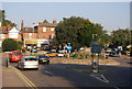
Looking SW to St. Stephen's Roundabout, Canterbury
Image: © N Chadwick
Taken: 27 Sep 2008
0.03 miles
5
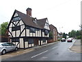
Kingsmead House, Canterbury
17th century house close to the city centre. Now a bed and breakfast establishment.
Image: © Graham Hogg
Taken: 23 Sep 2010
0.07 miles
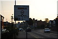
7
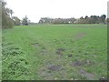
Former site of Canterbury City Stadium, Kingsmead Road
Planning permission has been granted by Canterbury City Council under application number CA/09/00818 for the “development of 140 residential units, provision of public open space with recreational field/play zone, highways, car parking, footpaths, cycle way and new river bridge”.
Image: © John Baker
Taken: 24 Nov 2013
0.07 miles
8
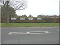
Banners on a hedge beside Kingsmead Road
From left to right, the banners read: No building,on our village?,green + pleasant, land. They refer to the field the other side of the hedge which was the Image
Image: © John Baker
Taken: 24 Nov 2013
0.07 miles
9
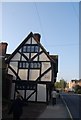
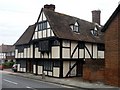
Kingsmead House
Built in 1620, now a B&B.
Image: © N Chadwick
Taken: 27 Sep 2008
0.08 miles