IMAGES TAKEN NEAR TO
Grebe Crescent, HYTHE, CT21 6QN
Introduction
This page details the photographs taken nearby to Grebe Crescent, CT21 6QN by members of the Geograph project.
The Geograph project started in 2005 with the aim of publishing, organising and preserving representative images for every square kilometre of Great Britain, Ireland and the Isle of Man.

There are currently over 7.5m images from over14,400 individuals and you can help contribute to the project by visiting https://www.geograph.org.uk
Image Map
Images are licensed for reuse under creativecommons.org/licenses/by-sa/2.0
Notes
- Clicking on the map will re-center to the selected point.
- The higher the marker number, the further away the image location is from the centre of the postcode.
Image Listing (61 Images Found)
Images are licensed for reuse under creativecommons.org/licenses/by-sa/2.0
Image
Details
Distance

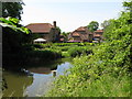
2
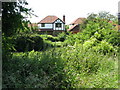
'Fairview' on the Burmarsh Road from the canal path
Image: © Nick Smith
Taken: 13 Jun 2009
0.03 miles

4
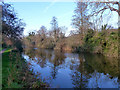
Royal Military Canal
Built as a line of defence rather than transport.
Image: © Robin Webster
Taken: 28 Dec 2015
0.06 miles

9
Houses in The Haven, a cul-de-sac off Burmarsh Road
Image: © Nick Smith
Taken: 13 Jun 2009
0.07 miles
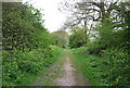
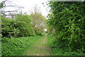
10

Canal path near Burmarsh Road
The path runs along the back of these houses on the Burmarsh Road
Image: © Nick Smith
Taken: 13 Jun 2009
0.08 miles