IMAGES TAKEN NEAR TO
Crofters Close, HYTHE, CT21 6QB
Introduction
This page details the photographs taken nearby to Crofters Close, CT21 6QB by members of the Geograph project.
The Geograph project started in 2005 with the aim of publishing, organising and preserving representative images for every square kilometre of Great Britain, Ireland and the Isle of Man.

There are currently over 7.5m images from over14,400 individuals and you can help contribute to the project by visiting https://www.geograph.org.uk
Image Map
Images are licensed for reuse under creativecommons.org/licenses/by-sa/2.0
Notes
- Clicking on the map will re-center to the selected point.
- The higher the marker number, the further away the image location is from the centre of the postcode.
Image Listing (96 Images Found)
Images are licensed for reuse under creativecommons.org/licenses/by-sa/2.0
Image
Details
Distance

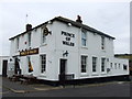
2
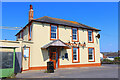
Prince of Wales
Public house on Dymchurch Road, Hythe.
Image: © Wayland Smith
Taken: 24 Apr 2022
0.10 miles
5
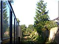
Hythe/Kent - 2008
Hythe, Pennypot, Romney, Hythe & Dymchurch Railway.
Image: © Helmut Zozmann
Taken: 5 Jul 2008
0.12 miles
7

Vintage 1978 Volkswagen Beetle, Dymchurch Road, Hythe
Image: © Chris Whippet
Taken: 28 Aug 2015
0.12 miles
8
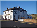
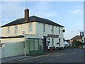
Prince of Wales Public House, Dymchurch Road.
Handy if out cycling or walking the Royal Military canal.
Image: © Kevin Woolterton
Taken: 2 Jan 2007
0.12 miles
9
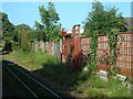
Hythe/Kent - 2008
Hythe, Pennypot, Romney, Hythe & Dymchurch Railway.
Image: © Helmut Zozmann
Taken: 5 Jul 2008
0.12 miles
10
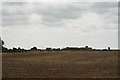
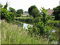
View along Botolph's Bridge Road towards the sea from the Romney, Hythe & Dymchurch Railway
Looking south-southeast.
Image: © Robert Lamb
Taken: 4 Sep 2016
0.12 miles