IMAGES TAKEN NEAR TO
Beach Flats, HYTHE, CT21 6JJ
Introduction
This page details the photographs taken nearby to Beach Flats, CT21 6JJ by members of the Geograph project.
The Geograph project started in 2005 with the aim of publishing, organising and preserving representative images for every square kilometre of Great Britain, Ireland and the Isle of Man.

There are currently over 7.5m images from over14,400 individuals and you can help contribute to the project by visiting https://www.geograph.org.uk
Image Map
Images are licensed for reuse under creativecommons.org/licenses/by-sa/2.0
Notes
- Clicking on the map will re-center to the selected point.
- The higher the marker number, the further away the image location is from the centre of the postcode.
Image Listing (441 Images Found)
Images are licensed for reuse under creativecommons.org/licenses/by-sa/2.0
Image
Details
Distance
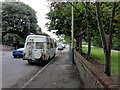
3
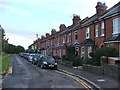
Hythe, St Nicholas Road
Hythe, St Nicholas Road seen from Dymchurch Road, A259.
Image: © Helmut Zozmann
Taken: 2 Aug 2011
0.03 miles
5
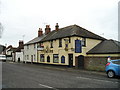
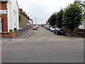
The Gate Inn Pub, Hythe
Dymchurch Road, HYTHE CT21 6JN close to The Royal Military Canal
Image: © canalandriversidepubs co uk
Taken: 13 Mar 2010
0.03 miles
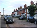
9
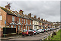
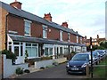
St Nicholas Road
Late Victorian/Early 20th Century terraced housing overlooking The Green.
Image: © Ian Capper
Taken: 14 Jan 2017
0.04 miles
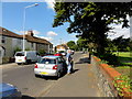
10
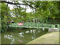
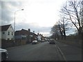
Footbridge over the Royal Military Canal
The bridge connects Military Road and Dymchurch Road.
Image: © pam fray
Taken: 18 Aug 2010
0.05 miles