IMAGES TAKEN NEAR TO
Coastguard Cottages, St. Leonards Road, HYTHE, CT21 6HN
Introduction
This page details the photographs taken nearby to Coastguard Cottages, St. Leonards Road, CT21 6HN by members of the Geograph project.
The Geograph project started in 2005 with the aim of publishing, organising and preserving representative images for every square kilometre of Great Britain, Ireland and the Isle of Man.

There are currently over 7.5m images from over14,400 individuals and you can help contribute to the project by visiting https://www.geograph.org.uk
Image Map
Images are licensed for reuse under creativecommons.org/licenses/by-sa/2.0
Notes
- Clicking on the map will re-center to the selected point.
- The higher the marker number, the further away the image location is from the centre of the postcode.
Image Listing (151 Images Found)
Images are licensed for reuse under creativecommons.org/licenses/by-sa/2.0
Image
Details
Distance
2
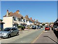
Hythe/Kent, West Parade
Hythe/Kent, West Parade, looking towards Theresa Road.
Image: © Helmut Zozmann
Taken: 17 Jul 2012
0.06 miles
8
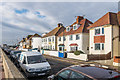
West Parade
1920s/30s housing. Beyond the nearest houses is a former Martello Tower, converted to housing in 1928 with further work to produce its current form in 1960.
A further Martello Tower can be seen in the distance.
Image: © Ian Capper
Taken: 14 Jan 2017
0.07 miles