IMAGES TAKEN NEAR TO
St. Leonards Road, HYTHE, CT21 6HE
Introduction
This page details the photographs taken nearby to St. Leonards Road, CT21 6HE by members of the Geograph project.
The Geograph project started in 2005 with the aim of publishing, organising and preserving representative images for every square kilometre of Great Britain, Ireland and the Isle of Man.

There are currently over 7.5m images from over14,400 individuals and you can help contribute to the project by visiting https://www.geograph.org.uk
Image Map
Images are licensed for reuse under creativecommons.org/licenses/by-sa/2.0
Notes
- Clicking on the map will re-center to the selected point.
- The higher the marker number, the further away the image location is from the centre of the postcode.
Image Listing (123 Images Found)
Images are licensed for reuse under creativecommons.org/licenses/by-sa/2.0
Image
Details
Distance
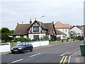
1
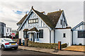
Lyndhurst
c.1930s house in St Leonards Road.
Image: © Ian Capper
Taken: 14 Jan 2017
0.00 miles
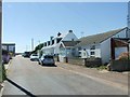

10
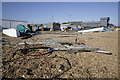
A working front, Hythe
Amazing amount of small fishing boats, nets and warehouses.
Image: © adam swaine
Taken: 1 Apr 2009
0.03 miles