IMAGES TAKEN NEAR TO
West Parade, HYTHE, CT21 6BX
Introduction
This page details the photographs taken nearby to West Parade, CT21 6BX by members of the Geograph project.
The Geograph project started in 2005 with the aim of publishing, organising and preserving representative images for every square kilometre of Great Britain, Ireland and the Isle of Man.

There are currently over 7.5m images from over14,400 individuals and you can help contribute to the project by visiting https://www.geograph.org.uk
Image Map
Images are licensed for reuse under creativecommons.org/licenses/by-sa/2.0
Notes
- Clicking on the map will re-center to the selected point.
- The higher the marker number, the further away the image location is from the centre of the postcode.
Image Listing (142 Images Found)
Images are licensed for reuse under creativecommons.org/licenses/by-sa/2.0
Image
Details
Distance
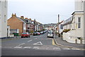
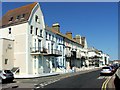
9
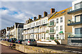
West Parade
Two late 19th Century terraces flanked by more modern housing.
Image: © Ian Capper
Taken: 14 Jan 2017
0.04 miles
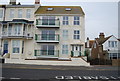
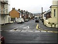
10
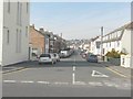
Ormonde Road, Hythe
Seen across West Parade.
Image: © John Baker
Taken: 7 Apr 2013
0.04 miles