IMAGES TAKEN NEAR TO
Stade Street, HYTHE, CT21 6BG
Introduction
This page details the photographs taken nearby to Stade Street, CT21 6BG by members of the Geograph project.
The Geograph project started in 2005 with the aim of publishing, organising and preserving representative images for every square kilometre of Great Britain, Ireland and the Isle of Man.

There are currently over 7.5m images from over14,400 individuals and you can help contribute to the project by visiting https://www.geograph.org.uk
Image Map (Loading...)


Getting Data...Please wait
Leaflet Map data © OpenStreetMap
Images are licensed for reuse under creativecommons.org/licenses/by-sa/2.0
Notes
- Clicking on the map will re-center to the selected point.
- The higher the marker number, the further away the image location is from the centre of the postcode.
Image Listing (473 Images Found)
Images are licensed for reuse under creativecommons.org/licenses/by-sa/2.0
Image
Details
Distance
2
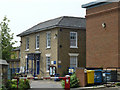
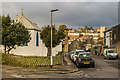
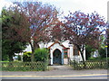
Hythe Town Council Building
On Stade Street. It is beside the Library (on left). It has a memorial stone on the right side which reads 'Borough of Hythe. This tablet is erected by the Town Council of Hythe in grateful remembrance of the late Dr Randall Davis. Who resided in this house. After a long life spent in the exercise of his profession with his gentle and kindly nature endeared him to all. He died on the 4th February 1932. Having by his will given his house and grounds to the borough.'
Image: © David Anstiss
Taken: 25 Apr 2009
0.01 miles
3
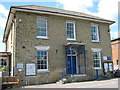
Hythe Library
On Stade Street. Seen from carpark and close to green beside the Canal.
Image: © David Anstiss
Taken: 25 Apr 2009
0.02 miles
5
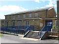
The Tin Tabernacle
Now an event space and art gallery, going by the name of the Tin Tabernacle.
It dates from 1893 when an "iron church" or "tin tabernacle" was erected on this site at the junction of Stade Street and Portland Road, as a mission church serving the community south of the Royal Military Canal, dedicated to St Michael and All Angels. It closed around 2012 and was bought by its present owners for its new use.
Grade II listed - see www.historicengland.org.uk/listing/the-list/list-entry/1393972.
On the right skyline is the tower of its original mother church, St Leonard's.
Image: © Ian Capper
Taken: 16 Jan 2017
0.03 miles
6
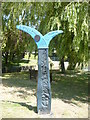
Milepost by the Royal Military Canal, Hythe
Situated to the east of the road bridge over the canal at the end of Stade Street. It is one of 1,000 mileposts funded by the Royal Bank of Scotland to mark the creation of the National Cycle Network.
Image: © pam fray
Taken: 23 Jun 2009
0.03 miles
7
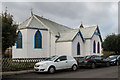
The Tin Tabernacle
Now an event space and art gallery, going by the name of the Tin Tabernacle.
It dates from 1893 when an "iron church" or "tin tabernacle" was erected on this site at the junction of Stade Street and Portland Road, as a mission church serving the community south of the Royal Military Canal, dedicated to St Michael and All Angels. It closed around 2012 and was bought by its present owners for its new use.
Grade II listed - see www.historicengland.org.uk/listing/the-list/list-entry/1393972.
Image: © Ian Capper
Taken: 16 Jan 2017
0.03 miles
8
St Michael's, Stade Street
St Michael's opened in 1893 and is an example of a 'tin tabernacle', prefabricated corrugated iron churches built to service the rapidly expanding urban areas of Britain in the Victorian era of the 19th century.
A grade II listed building.
Image: © E Gammie
Taken: 7 Jul 2010
0.03 miles
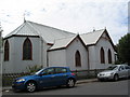
9
Entrance to St Michael's church
At the junction of Stade Street and Portland Street. A prefabricated corrugated iron 'tin tabernacle' opened in 1893 to serve an expanding urban area of the time. Looking in remarkably good condition and obviously still serving the local area.
Image: © E Gammie
Taken: 7 Jul 2010
0.03 miles
10
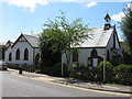
St Michael's Church
At the end of Stade Street. Corrugated iron clad church in Parish of St. Leonard.
Image: © David Anstiss
Taken: 25 Apr 2009
0.03 miles