IMAGES TAKEN NEAR TO
Blackhouse Hill, HYTHE, CT21 5UR
Introduction
This page details the photographs taken nearby to Blackhouse Hill, CT21 5UR by members of the Geograph project.
The Geograph project started in 2005 with the aim of publishing, organising and preserving representative images for every square kilometre of Great Britain, Ireland and the Isle of Man.

There are currently over 7.5m images from over14,400 individuals and you can help contribute to the project by visiting https://www.geograph.org.uk
Image Map
Images are licensed for reuse under creativecommons.org/licenses/by-sa/2.0
Notes
- Clicking on the map will re-center to the selected point.
- The higher the marker number, the further away the image location is from the centre of the postcode.
Image Listing (50 Images Found)
Images are licensed for reuse under creativecommons.org/licenses/by-sa/2.0
Image
Details
Distance
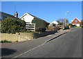
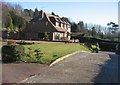
1
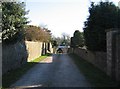
Access to new homes
This paved lane leads to two new large houses built in the gardens of the houses on Blackhouse Hill. Someone cashed in.
Image: © Mr Ignavy
Taken: 17 Feb 2008
0.01 miles
2
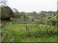
Former vegetable garden
Dug over many times by this photographer.
Image: © Fernweh
Taken: 17 Apr 2019
0.02 miles
3
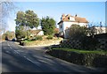
Blackhouse Hill homes
Thirty years ago these houses were hidden by large trees - it was extremely dangerous turning into or out of their drive ways.
Image: © Mr Ignavy
Taken: 17 Feb 2008
0.02 miles
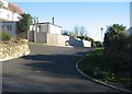
4
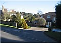
Bassett Gardens
This plot of land was once a garden. As a child I knew it as the 'Italian Garden' - there was a large ornamental square pool in the middle of the plot as well as an ornate staircase coming down the hill from the main house. Now there are three houses.
Image: © Mr Ignavy
Taken: 17 Feb 2008
0.03 miles
6
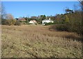
Field & housing
The modern house to the left of the photo is the last house in Bassett Close. The other two houses are accessed via a private track.
Image: © Mr Ignavy
Taken: 17 Feb 2008
0.04 miles
7
House in Bassett Close
The builders managed to retain some of the former architecture from the site as seen by the two urns on the gate posts. This plot of land used to be a tennis court.
Image: © Mr Ignavy
Taken: 17 Feb 2008
0.04 miles
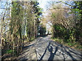
8

Blackhouse Hill
Although there are only a few homes off the hill beyond this point the footpath is very important as it links with a public footpath further up the hill which goes across the farmland to Saltwood.
Image: © Mr Ignavy
Taken: 17 Feb 2008
0.05 miles