IMAGES TAKEN NEAR TO
Lower Corniche, HYTHE, CT21 5TP
Introduction
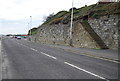
This page details the photographs taken nearby to Lower Corniche, CT21 5TP by members of the Geograph project.
The Geograph project started in 2005 with the aim of publishing, organising and preserving representative images for every square kilometre of Great Britain, Ireland and the Isle of Man.

There are currently over 7.5m images from over14,400 individuals and you can help contribute to the project by visiting https://www.geograph.org.uk
Image Map
Images are licensed for reuse under creativecommons.org/licenses/by-sa/2.0
Notes
- Clicking on the map will re-center to the selected point.
- The higher the marker number, the further away the image location is from the centre of the postcode.
Image Listing (124 Images Found)
Images are licensed for reuse under creativecommons.org/licenses/by-sa/2.0
Image
Details
Distance
1
Seascape, Sandgate Esplanade
The building work of this block of apartments has been completed. I last photographed it when it was Image
Image: © John Baker
Taken: 2 Mar 2014
0.01 miles
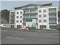
2
Building in progress, Sandgate Esplanade
This will be known as Seascape upon completion and is to comprise of fourteen two and three bedroom apartments constructed by Kentish Projects Ltd with a guide price from £340,000 - £550.000 leasehold. The sole agents are C R Child and Partners http://www.crchildandpartners.co.uk
This is how the site looked in David Anstiss' picture Image
Image: © John Baker
Taken: 5 May 2013
0.02 miles
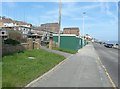
3
Sandgate - 2014
Sandgate, Kent, Sandgate Esplanade, A259, remains of Sandgate Branch Railway Line.
The Sandgate branch was a three mile long railway branch line that ran from Sandling railway station in Kent on the South Eastern Main Line to Hythe and Sandgate railway stations. It opened in 1874 and closed completely in 1951.
Image: © Helmut Zozmann
Taken: 4 Oct 2014
0.02 miles
4
Sandgate - 2014
Sandgate, Kent, Sandgate Esplanade, A259, remains of Sandgate Branch Railway Line.
The Sandgate branch was a three mile long railway branch line that ran from Sandling railway station in Kent on the South Eastern Main Line to Hythe and Sandgate railway stations. It opened in 1874 and closed completely in 1951.
Image: © Helmut Zozmann
Taken: 4 Oct 2014
0.02 miles
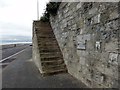
5
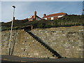
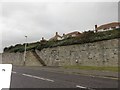
Steps to nowhere
These brick steps are on Sandgate Esplanade.
Have been informed these steps used to lead to Sandgate station.
Image: © David Anstiss
Taken: 19 Nov 2010
0.02 miles
6
Sandgate - 2014
Sandgate, Kent, Sandgate Esplanade, A259, remains of Sandgate Branch Railway Line.
The Sandgate branch was a three mile long railway branch line that ran from Sandling railway station in Kent on the South Eastern Main Line to Hythe and Sandgate railway stations. It opened in 1874 and closed completely in 1951.
Image: © Helmut Zozmann
Taken: 4 Oct 2014
0.03 miles
8
Sandgate - 2014
Sandgate, Kent, Sandgate Esplanade, A259, remains of Sandgate Branch Railway Line.
The Sandgate branch was a three mile long railway branch line that ran from Sandling railway station in Kent on the South Eastern Main Line to Hythe and Sandgate railway stations. It opened in 1874 and closed completely in 1951.
Image: © Helmut Zozmann
Taken: 4 Oct 2014
0.03 miles
9
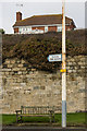
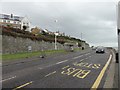
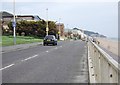
591 metres
Sign on The Esplanade showing what seems to be an unnecessarily precise distance to the next toilets. The reason for the sign here is presumably because it is near the site of a former toilet block (see Image), but I would have thought that most people would be happy (or unhappy?) to be told that it was 600m or so to the nearest ones.
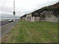
The wall in the background is from the Shorncliffe Battery, built to protect the eastern end of the Royal Military Canal. It is a scheduled monument - see www.historicengland.org.uk/listing/the-list/list-entry/1005117.
Image: © Ian Capper
Taken: 16 Jan 2017
0.04 miles