IMAGES TAKEN NEAR TO
Spring Lane, HYTHE, CT21 5TH
Introduction
This page details the photographs taken nearby to Spring Lane, CT21 5TH by members of the Geograph project.
The Geograph project started in 2005 with the aim of publishing, organising and preserving representative images for every square kilometre of Great Britain, Ireland and the Isle of Man.

There are currently over 7.5m images from over14,400 individuals and you can help contribute to the project by visiting https://www.geograph.org.uk
Image Map
Images are licensed for reuse under creativecommons.org/licenses/by-sa/2.0
Notes
- Clicking on the map will re-center to the selected point.
- The higher the marker number, the further away the image location is from the centre of the postcode.
Image Listing (21 Images Found)
Images are licensed for reuse under creativecommons.org/licenses/by-sa/2.0
Image
Details
Distance
1
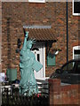
Statue of Liberty in Hythe
Somebody on Spring Lane, loves New York and USA a bit too much!!
Image: © David Anstiss
Taken: 19 Nov 2010
0.03 miles
2
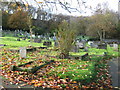
Spring Lane Cemetery
Small cemetery at the end of the lane. Paraker Wood is in the background.
Image: © David Anstiss
Taken: 19 Nov 2010
0.05 miles
3
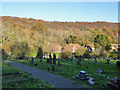
Spring Lane Cemetery
On a steeply sloping site at the end of Spring Lane.
Image: © Robin Webster
Taken: 18 Nov 2018
0.05 miles
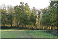
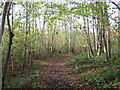
4
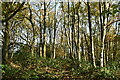
Woodland Track in Paraker Wood
A track in the woodland near Sene Farm.
Image: © David Anstiss
Taken: 19 Nov 2010
0.06 miles
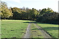
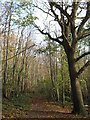
5
Footpath in Paraker Wood
This woodland path leads from Spring Lane towards Sene Farm
Image: © David Anstiss
Taken: 19 Nov 2010
0.07 miles
6
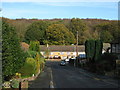
Highridge and Spring Lane junction
Highridge leads from Naildown Road. Spring Lane leads from Horn Street.
In the background is Paraker Wood.
Image: © David Anstiss
Taken: 19 Nov 2010
0.09 miles
8
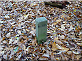
Boundary stone (?), Spring Lane Cemetery
This quite modern stone is not on any mapped administrative boundary, so presumably marks the limit of the cemetery land, which tails off into woodland with no other clear boundary. It could be a grave, but it is an odd marker, a long way from any other graves. I don't know what H. B.B. stands for.
Image: © Robin Webster
Taken: 18 Nov 2018
0.12 miles