IMAGES TAKEN NEAR TO
Hampton Vale, HYTHE, CT21 5SG
Introduction
This page details the photographs taken nearby to Hampton Vale, CT21 5SG by members of the Geograph project.
The Geograph project started in 2005 with the aim of publishing, organising and preserving representative images for every square kilometre of Great Britain, Ireland and the Isle of Man.

There are currently over 7.5m images from over14,400 individuals and you can help contribute to the project by visiting https://www.geograph.org.uk
Image Map
Images are licensed for reuse under creativecommons.org/licenses/by-sa/2.0
Notes
- Clicking on the map will re-center to the selected point.
- The higher the marker number, the further away the image location is from the centre of the postcode.
Image Listing (41 Images Found)
Images are licensed for reuse under creativecommons.org/licenses/by-sa/2.0
Image
Details
Distance
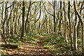
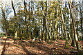
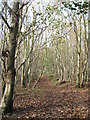
3
Woodland Track in Paraker Wood
Leading from a footpath in the wood to another footpath.
Image: © David Anstiss
Taken: 19 Nov 2010
0.09 miles
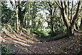
4
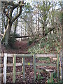
Stile near Paraker Wood
Paraker Lane (footpath/track) from Horn Street heads into the wood and then divides. A path leads straight on through the wood towards Sene Wood. Another path leads left also through the wood to another footpath to Sene Farm.
Image: © David Anstiss
Taken: 19 Nov 2010
0.09 miles

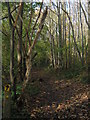
9
Footpath in Paraker Wood
This path in the wood leads from Paraker Lane towards Sene Farm.
Image: © David Anstiss
Taken: 19 Nov 2010
0.11 miles