IMAGES TAKEN NEAR TO
Sandy Lane, HYTHE, CT21 5RX
Introduction
This page details the photographs taken nearby to Sandy Lane, CT21 5RX by members of the Geograph project.
The Geograph project started in 2005 with the aim of publishing, organising and preserving representative images for every square kilometre of Great Britain, Ireland and the Isle of Man.

There are currently over 7.5m images from over14,400 individuals and you can help contribute to the project by visiting https://www.geograph.org.uk
Image Map
Images are licensed for reuse under creativecommons.org/licenses/by-sa/2.0
Notes
- Clicking on the map will re-center to the selected point.
- The higher the marker number, the further away the image location is from the centre of the postcode.
Image Listing (116 Images Found)
Images are licensed for reuse under creativecommons.org/licenses/by-sa/2.0
Image
Details
Distance
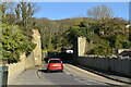
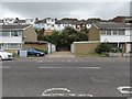
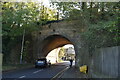
2
Seabrook - 2014
Hythe, Kent, Seabrook, Hospital Hill, remains of old Sandgate Branch Railway Bridge.
The Sandgate branch was a three mile long railway branch line that ran from Sandling railway station in Kent on the South Eastern Main Line to Hythe and Sandgate railway stations. It opened in 1874 and closed completely in 1951.
Image: © Helmut Zozmann
Taken: 4 Oct 2014
0.03 miles
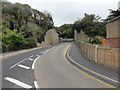
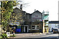
4
Partially dismantled railway bridge over Hospital Hill
The B2063 road leads from Seabrook Road up towards Cheriton.
The railway bridge was once used by the dismantled Hythe and Sandgate Railway.
Image: © David Anstiss
Taken: 19 Nov 2010
0.05 miles
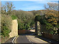
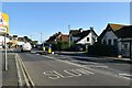
5
Seabrook - 2014
Hythe, Kent, Seabrook, Seabrook Road, A259, remains of Sandgate Branch Railway Line visible behind the houses.
The Sandgate branch was a three mile long railway branch line that ran from Sandling railway station in Kent on the South Eastern Main Line to Hythe and Sandgate railway stations. It opened in 1874 and closed completely in 1951.
Image: © Helmut Zozmann
Taken: 4 Oct 2014
0.06 miles
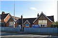
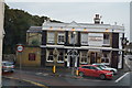
10
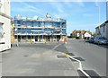
Fountain Public House, 171 Seabrook Road
Closed for refurbishment at the time of my visit but hoped to reopen soon.
Image: © John Baker
Taken: 5 May 2013
0.06 miles