IMAGES TAKEN NEAR TO
Seabrook Road, HYTHE, CT21 5RA
Introduction
This page details the photographs taken nearby to Seabrook Road, CT21 5RA by members of the Geograph project.
The Geograph project started in 2005 with the aim of publishing, organising and preserving representative images for every square kilometre of Great Britain, Ireland and the Isle of Man.

There are currently over 7.5m images from over14,400 individuals and you can help contribute to the project by visiting https://www.geograph.org.uk
Image Map
Images are licensed for reuse under creativecommons.org/licenses/by-sa/2.0
Notes
- Clicking on the map will re-center to the selected point.
- The higher the marker number, the further away the image location is from the centre of the postcode.
Image Listing (95 Images Found)
Images are licensed for reuse under creativecommons.org/licenses/by-sa/2.0
Image
Details
Distance
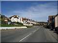
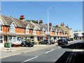
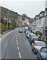
1
A259 Seabrook Road
Heading west towards Hythe.
Image: © Robin Webster
Taken: 18 Nov 2018
0.01 miles
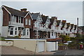
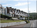
2
Houses at Seabrook, Kent
Photograph taken from the sea front. The Royal Military Canal runs in front of the houses.
Image: © Peter Trimming
Taken: 17 Jun 2009
0.05 miles
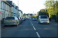
5
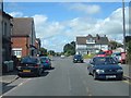
Hythe, Seabrook, Seabrook Road (A259)
Image: © Helmut Zozmann
Taken: 5 Jul 2008
0.07 miles
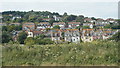
6
Looking eastwards along the Royal Military Canal from the Seaview Footbridge
The start of the canal and houses on Seabrook Road are in the distance.
Image: © pam fray
Taken: 3 Apr 2012
0.07 miles
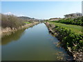
9
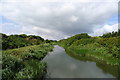
The Royal Military Canal, Seabrook, Hythe
Near its eastern end at the outskirts of Folkestone.
Image: © Tim Heaton
Taken: 8 Aug 2019
0.08 miles