IMAGES TAKEN NEAR TO
Seabrook Road, HYTHE, CT21 5QP
Introduction
This page details the photographs taken nearby to Seabrook Road, CT21 5QP by members of the Geograph project.
The Geograph project started in 2005 with the aim of publishing, organising and preserving representative images for every square kilometre of Great Britain, Ireland and the Isle of Man.

There are currently over 7.5m images from over14,400 individuals and you can help contribute to the project by visiting https://www.geograph.org.uk
Image Map
Images are licensed for reuse under creativecommons.org/licenses/by-sa/2.0
Notes
- Clicking on the map will re-center to the selected point.
- The higher the marker number, the further away the image location is from the centre of the postcode.
Image Listing (84 Images Found)
Images are licensed for reuse under creativecommons.org/licenses/by-sa/2.0
Image
Details
Distance
2
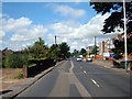
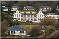
Hythe, Seabrook, Seabrook Road (A259)
Image: © Helmut Zozmann
Taken: 5 Jul 2008
0.06 miles
3
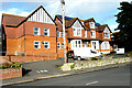
Cedar House, 93, Seabrook Road
Planning permission has been approved, with conditions, by Folkestone and Hythe District Council under application number 21/0715/FH for the “demolition of an existing single storey extension and conversion of an existing 27 bed residential care home and 1, 2 bed ancillary maisonette on the second floor, into 8 self-contained 2 bed flats”.
Image: © John Baker
Taken: 6 Feb 2022
0.07 miles
4
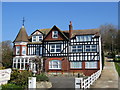
Seabrook House
Bed and Breakfast accommodation on Seabrook Road, near Hythe.
Image: © Chris Heaton
Taken: 1 May 2013
0.09 miles
5
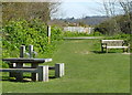
Picnic Site on the northern side of the Royal Military Canal
Image: © pam fray
Taken: 3 Apr 2012
0.10 miles
6
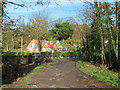
Cliff Road bridge
Cliff Road leads from Seabrook towards Blackhouse Hill (road).
It leads over the dismantled (and now built on) Hythe and Sandgate Railway.
Image: © David Anstiss
Taken: 19 Nov 2010
0.10 miles
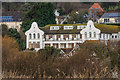
7
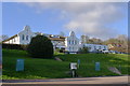
Spire St Saviour's Hospital, Seabrook Road, Hythe
Private hospital run by Spire Healthcare (but closed in 2015, as too expensive to modernise)
"The hospital ... was founded when William Lidderdale, then governor of the Bank of England, bought a building near Regent's Park after being inspired by stories of Florence Nightingale's heroics during the Crimean War. The hospital was moved to Hythe in 1962 and was run by nuns until the 1970s." https://www.thetimes.co.uk/article/spire-to-shut-st-saviours-hospital-23wpwrz8p3v
Image: © Tim Heaton
Taken: 30 Apr 2013
0.10 miles
8
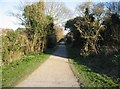
Footpath to Seabrook
Along the north side of the military canal.
Image: © Mr Ignavy
Taken: 16 Feb 2008
0.11 miles
9
St Saviour's Hospital
The former St Saviour's Hospital seen from Princes Parade. The hospital closed on 25 September 2015 and plans have been submitted for its demolition and replacement with housing.
Image: © Ian Capper
Taken: 16 Jan 2017
0.11 miles
10
St Saviour's Hospital
The former St Saviour's Hospital seen from Princes Parade. The hospital closed on 25 September 2015 and plans have been submitted for its demolition and replacement with housing.
Image: © Ian Capper
Taken: 16 Jan 2017
0.11 miles