IMAGES TAKEN NEAR TO
Seabrook Road, HYTHE, CT21 5QN
Introduction
This page details the photographs taken nearby to Seabrook Road, CT21 5QN by members of the Geograph project.
The Geograph project started in 2005 with the aim of publishing, organising and preserving representative images for every square kilometre of Great Britain, Ireland and the Isle of Man.

There are currently over 7.5m images from over14,400 individuals and you can help contribute to the project by visiting https://www.geograph.org.uk
Image Map
Images are licensed for reuse under creativecommons.org/licenses/by-sa/2.0
Notes
- Clicking on the map will re-center to the selected point.
- The higher the marker number, the further away the image location is from the centre of the postcode.
Image Listing (83 Images Found)
Images are licensed for reuse under creativecommons.org/licenses/by-sa/2.0
Image
Details
Distance
1
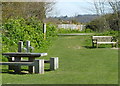
Picnic Site on the northern side of the Royal Military Canal
Image: © pam fray
Taken: 3 Apr 2012
0.05 miles
2
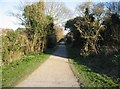
Footpath to Seabrook
Along the north side of the military canal.
Image: © Mr Ignavy
Taken: 16 Feb 2008
0.05 miles
3
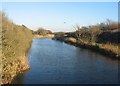
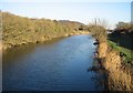
Royal Military Canal
The bend in the canal can be clearly seen in this photo. This was a deliberate design to allow soldiers to fire down the length of the canal should any invaders approach by boat.
Image: © Mr Ignavy
Taken: 16 Feb 2008
0.07 miles
5
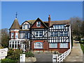
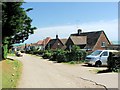
Seabrook House
Bed and Breakfast accommodation on Seabrook Road, near Hythe.
Image: © Chris Heaton
Taken: 1 May 2013
0.07 miles
6
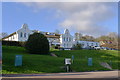
Spire St Saviour's Hospital, Seabrook Road, Hythe
Private hospital run by Spire Healthcare (but closed in 2015, as too expensive to modernise)
"The hospital ... was founded when William Lidderdale, then governor of the Bank of England, bought a building near Regent's Park after being inspired by stories of Florence Nightingale's heroics during the Crimean War. The hospital was moved to Hythe in 1962 and was run by nuns until the 1970s." https://www.thetimes.co.uk/article/spire-to-shut-st-saviours-hospital-23wpwrz8p3v
Image: © Tim Heaton
Taken: 30 Apr 2013
0.08 miles
7
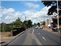
Hythe, Seabrook, Seabrook Road (A259)
Image: © Helmut Zozmann
Taken: 5 Jul 2008
0.08 miles
8
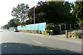
Hoarding, Seabrook Road
The hoarding hides the grounds and buildings of Image for which planning permission has been granted, with conditions, by Folkestone and Hythe District Council under application number Y16/0794/SH for an “outline consent for the demolition of the main hospital buildings and outbuildings to provide for up to 47 residential units, associated car parking and landscaping”.
Image: © John Baker
Taken: 17 Sep 2023
0.09 miles
9
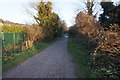
Royal Military Canal Path towards Seabrook Road
Image: © Ian S
Taken: 14 Dec 2019
0.09 miles