IMAGES TAKEN NEAR TO
Seabrook Road, HYTHE, CT21 5QA
Introduction
This page details the photographs taken nearby to Seabrook Road, CT21 5QA by members of the Geograph project.
The Geograph project started in 2005 with the aim of publishing, organising and preserving representative images for every square kilometre of Great Britain, Ireland and the Isle of Man.

There are currently over 7.5m images from over14,400 individuals and you can help contribute to the project by visiting https://www.geograph.org.uk
Image Map
Images are licensed for reuse under creativecommons.org/licenses/by-sa/2.0
Notes
- Clicking on the map will re-center to the selected point.
- The higher the marker number, the further away the image location is from the centre of the postcode.
Image Listing (74 Images Found)
Images are licensed for reuse under creativecommons.org/licenses/by-sa/2.0
Image
Details
Distance
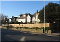
3
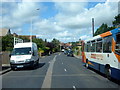
Hythe, Seabrook Road
Hythe, Seabrook Road, A259.
Image: © Helmut Zozmann
Taken: 17 Jul 2012
0.04 miles
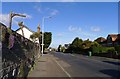
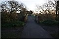
5
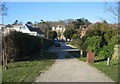
Access track to military canal
Just off Seabrook Road, opposite Cannongate Road.
Image: © Mr Ignavy
Taken: 16 Feb 2008
0.05 miles
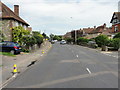
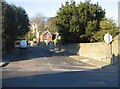
6
Hythe, Seabrook, Seabrook Road (A259)
Image: © Helmut Zozmann
Taken: 5 Jul 2008
0.05 miles
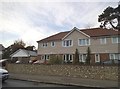
8
Cannongate Bridge over the Royal Military Canal and surrounding footpaths
Image: © Tom Page
Taken: 12 Feb 2022
0.07 miles
9
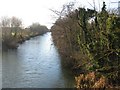
Canal view
Looking west towards Hythe town centre.
Image: © Mr Ignavy
Taken: 16 Feb 2008
0.07 miles
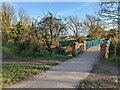
10
Footbridge over the Royal Military Canal near Seabrook
Image: © Ian S
Taken: 14 Dec 2019
0.08 miles