IMAGES TAKEN NEAR TO
Mill Road, HYTHE, CT21 5LP
Introduction
This page details the photographs taken nearby to Mill Road, CT21 5LP by members of the Geograph project.
The Geograph project started in 2005 with the aim of publishing, organising and preserving representative images for every square kilometre of Great Britain, Ireland and the Isle of Man.

There are currently over 7.5m images from over14,400 individuals and you can help contribute to the project by visiting https://www.geograph.org.uk
Image Map
Images are licensed for reuse under creativecommons.org/licenses/by-sa/2.0
Notes
- Clicking on the map will re-center to the selected point.
- The higher the marker number, the further away the image location is from the centre of the postcode.
Image Listing (133 Images Found)
Images are licensed for reuse under creativecommons.org/licenses/by-sa/2.0
Image
Details
Distance
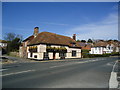
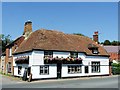
4
The Bell Inn Pub, Hythe
Seabrook Road, HYTHE CT21 5NB near to The Royal Military Canal
Image: © canalandriversidepubs co uk
Taken: 13 Mar 2010
0.03 miles
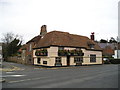
7
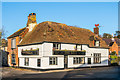
The Bell
Early 18th Century front on an older timber framed building. Grade II listed - see www.historicengland.org.uk/listing/the-list/list-entry/1116490
Image: © Ian Capper
Taken: 14 Jan 2017
0.04 miles
8
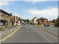
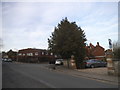
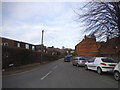
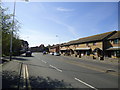
Hythe, East Street
Hythe, East Street, A259.
Image: © Helmut Zozmann
Taken: 17 Jul 2012
0.04 miles