IMAGES TAKEN NEAR TO
Prospect Road, HYTHE, CT21 5FH
Introduction
This page details the photographs taken nearby to Prospect Road, CT21 5FH by members of the Geograph project.
The Geograph project started in 2005 with the aim of publishing, organising and preserving representative images for every square kilometre of Great Britain, Ireland and the Isle of Man.

There are currently over 7.5m images from over14,400 individuals and you can help contribute to the project by visiting https://www.geograph.org.uk
Image Map
Images are licensed for reuse under creativecommons.org/licenses/by-sa/2.0
Notes
- Clicking on the map will re-center to the selected point.
- The higher the marker number, the further away the image location is from the centre of the postcode.
Image Listing (470 Images Found)
Images are licensed for reuse under creativecommons.org/licenses/by-sa/2.0
Image
Details
Distance
1
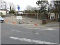
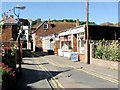
Proposed building site, Prospect Road
Planning permission has been approved, with conditions, by Folkestone and Hythe District Council under application number Y15/0467/SH for the “erection of a three storey residential development comprising nine apartments and one maisonette, with understorey parking and associated landscaping, following demolition of the existing building”. This development is on the site of The Paddocks, 13, Prospect Road. The nameplate, bearing the name of the former house, is still attached to the brick pillar, surmounted with the large concrete ball, on the right hand side of the view.
Image: © John Baker
Taken: 19 Mar 2017
0.00 miles
2
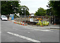
Building site, Prospect Road
Planning permission has been approved, with conditions, by Folkestone and Hythe District Council under application number Y15/0467/SH for the “erection of a three storey residential development comprising nine apartments and one maisonette, with understorey parking and associated landscaping, following demolition of the existing building”. This development is on the site of The Paddocks, 13, Prospect Road. The nameplate, bearing the name of the former house, is still attached to the brick pillar, surmounted with the large concrete ball, on the right hand side of the frame. My previous visit showed this development as a Image
Image: © John Baker
Taken: 11 Jun 2017
0.01 miles
4
Marine Walk Street, Hythe in 1968
Prominently situated on the hillside above is St Leonard's church.
Image: © John Baker
Taken: Unknown
0.03 miles
6
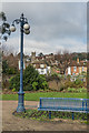
Lamp and seat
Lamp and seat by the War Memorial. In the background is St Leonard's Church.
Image: © Ian Capper
Taken: 16 Jan 2017
0.03 miles
7
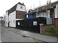
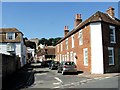
Conversion of number 4 Marine Walk Street
Planning permission has been approved, with conditions, by Folkestone and Hythe District Council under application number Y13/0038/SH for the “change of use and conversion from existing restaurant/take-away (Class A3) to single dwelling including provision of bay window to front elevation and other alterations”.
Image: © John Baker
Taken: 2 Mar 2014
0.03 miles
8
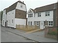
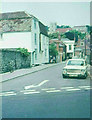
4 Marine Walk Street
In March 2014, the Image was taking place. The building work has now been completed but the house didn’t seem to be occupied. The building to its left is Barley House.
Image: © John Baker
Taken: 20 Jul 2014
0.03 miles
10
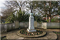
Hythe War Memorial
Unveiled on 16 July 1921 initially as a memorial to the men of Hythe who died in the First World War. It was sculpted by Gilbert Bayes. Grade II* listed - see www.historicengland.org.uk/listing/the-list/list-entry/1430450.
Image: © Ian Capper
Taken: 16 Jan 2017
0.03 miles