IMAGES TAKEN NEAR TO
Hillside Street, HYTHE, CT21 5EW
Introduction
This page details the photographs taken nearby to Hillside Street, CT21 5EW by members of the Geograph project.
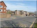
The Geograph project started in 2005 with the aim of publishing, organising and preserving representative images for every square kilometre of Great Britain, Ireland and the Isle of Man.

There are currently over 7.5m images from over14,400 individuals and you can help contribute to the project by visiting https://www.geograph.org.uk
Image Map
Images are licensed for reuse under creativecommons.org/licenses/by-sa/2.0
Notes
- Clicking on the map will re-center to the selected point.
- The higher the marker number, the further away the image location is from the centre of the postcode.
Image Listing (392 Images Found)
Images are licensed for reuse under creativecommons.org/licenses/by-sa/2.0
Image
Details
Distance
1
Regency Court
Town houses (No's 40,40A and 42, 42A) on Bartholomew Street.
Image: © David Anstiss
Taken: 13 Nov 2010
0.05 miles
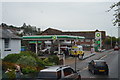
2
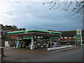
BP Petrol Filling Station
On Military Road.
Image: © David Anstiss
Taken: 13 Nov 2010
0.07 miles
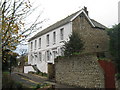
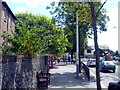
3
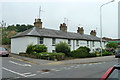
Military Terrace, Hythe
A mid 19th century grade II listed building.
Image: © Robin Webster
Taken: 13 Jul 2013
0.08 miles
4
Findley and Mackeson Courts
Findley Court (on the left) and Mackeson Court (on the right) are situated on Military Road. To the left of the latter building, the tower of St Leonard's church is visible in the distance.
Image: © John Baker
Taken: 7 Apr 2013
0.09 miles
5
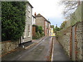
Hillside, Hythe
One of the narrow lanes on the hill above Hythe.
Image: © David Anstiss
Taken: 13 Nov 2010
0.09 miles
6

Old Boundary Marker on Military Road, Hythe
War Department Estate Boundary Marker on the northeast side of the T junction of the A259 Military Road and Sir John Moore Avenue. Hythe parish. Probably inscribed below pavement level W D / ↑ / No 1, marking the former boundary of the School of Musketry which was established in Hythe in 1853.
Milestone Society National ID: KE_WDHYTH01em
Image: © P Collins
Taken: 15 Jan 2022
0.09 miles
8
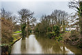
Royal Military Canal
Looking west along the Royal Military Canal from the Dymchurch Road bridge.
Image: © Ian Capper
Taken: 14 Jan 2017
0.10 miles
9
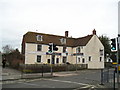
The Dukes Head Pub, Hythe
Dymchurch Road, HYTHE CT21 6JB near to The Royal Military Canal
Image: © canalandriversidepubs co uk
Taken: 13 Mar 2010
0.10 miles