IMAGES TAKEN NEAR TO
Sir John Moore Avenue, HYTHE, CT21 5BZ
Introduction
This page details the photographs taken nearby to Sir John Moore Avenue, CT21 5BZ by members of the Geograph project.
The Geograph project started in 2005 with the aim of publishing, organising and preserving representative images for every square kilometre of Great Britain, Ireland and the Isle of Man.

There are currently over 7.5m images from over14,400 individuals and you can help contribute to the project by visiting https://www.geograph.org.uk
Image Map
Images are licensed for reuse under creativecommons.org/licenses/by-sa/2.0
Notes
- Clicking on the map will re-center to the selected point.
- The higher the marker number, the further away the image location is from the centre of the postcode.
Image Listing (365 Images Found)
Images are licensed for reuse under creativecommons.org/licenses/by-sa/2.0
Image
Details
Distance
1
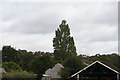
View of houses on the hill from Hythe station on the Romney, Hythe & Dymchurch Railway
Looking north-northeast.
Image: © Robert Lamb
Taken: 4 Sep 2016
0.03 miles
2
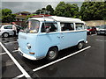
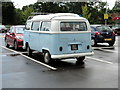
Hythe, Kent
Hythe (Kent), 19 Military Road, Carpark Sainsbury's Supermarket. 1972 built, 1600 cc, Volkswagen Type 2 T2 Motorcaravan.
Image: © Helmut Zozmann
Taken: 14 Jul 2012
0.06 miles
3
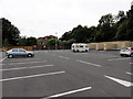
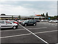
Hythe, Military Road
Hythe, Sainbury's Superstore Car Park, Military Road, CT21 5BH
Image: © Helmut Zozmann
Taken: 12 Jul 2011
0.06 miles
4
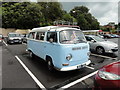
Hythe, Kent
Hythe (Kent), 19 Military Road, Carpark Sainsbury's Supermarket. 1972 built, 1600 cc, Volkswagen Type 2 T2 Motorcaravan.
Image: © Helmut Zozmann
Taken: 14 Jul 2012
0.07 miles
5
Hythe, Kent
Hythe (Kent), 19 Military Road, Carpark Sainsbury's Supermarket. 1972 built, 1600 cc, Volkswagen Type 2 T2 Motorcaravan.
Image: © Helmut Zozmann
Taken: 14 Jul 2012
0.08 miles
6

Extension to Park Lodge, Barrack Hill
Planning permission has been approved, with conditions, by Folkestone and Hythe District Council under application number Y13/1282/SH for the “extension and conversion of garage to residential dwelling”. This is Image with its new extension.
Image: © John Baker
Taken: 7 Feb 2016
0.08 miles
7

Park Lodge, Barrack Hill
The basic structure of the Image seems to have been completed, although there is still some scaffolding to be removed. Planning permission was approved, with conditions, by Folkestone and Hythe District Council under application number Y13/1282/SH as the “extension and conversion of garage to residential dwelling”.
Image: © John Baker
Taken: 19 Mar 2017
0.08 miles
8
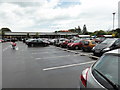
Hythe, Military Road
Hythe, Sainbury's Superstore Car Park, Military Road, CT21 5BH
Image: © Helmut Zozmann
Taken: 12 Jul 2011
0.09 miles
9
Hythe, Kent
Hythe (Kent), 19 Military Road, Carpark Sainsbury's Supermarket.
Image: © Helmut Zozmann
Taken: 14 Jul 2012
0.09 miles
10
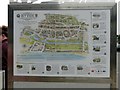
Hythe - 2015
Hythe, Kent, Military Road, A259, Sainsbury's car park, Hythe Town Map
Image: © Helmut Zozmann
Taken: 11 Aug 2015
0.09 miles