IMAGES TAKEN NEAR TO
Military Road, HYTHE, CT21 5AS
Introduction
This page details the photographs taken nearby to Military Road, CT21 5AS by members of the Geograph project.
The Geograph project started in 2005 with the aim of publishing, organising and preserving representative images for every square kilometre of Great Britain, Ireland and the Isle of Man.

There are currently over 7.5m images from over14,400 individuals and you can help contribute to the project by visiting https://www.geograph.org.uk
Image Map
Images are licensed for reuse under creativecommons.org/licenses/by-sa/2.0
Notes
- Clicking on the map will re-center to the selected point.
- The higher the marker number, the further away the image location is from the centre of the postcode.
Image Listing (302 Images Found)
Images are licensed for reuse under creativecommons.org/licenses/by-sa/2.0
Image
Details
Distance
1
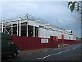
Construction of Sainsbury's Superstore, Hythe
A former offices on Military Road, has been demolished and a controversial new supermarket is being built.
Image: © David Anstiss
Taken: 13 Nov 2010
0.01 miles
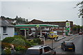
3
Sainsbury's Supermarket, Hythe
Formerly the site of offices on Military Road which were demolished and this new store built.
Compare with Image
Image: © David Anstiss
Taken: 3 Sep 2011
0.03 miles
4
Small Arms School Memorial
Recently erected memorial. The Small Arms School was in Hythe from 1919 to 1969. Prior to that it was known as the School of Musketry.
Image: © Kevin Woolterton
Taken: 13 Nov 2013
0.04 miles
5
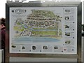
Hythe - 2015
Hythe, Kent, Military Road, A259, Sainsbury's car park, Hythe Town Map
Image: © Helmut Zozmann
Taken: 11 Aug 2015
0.04 miles
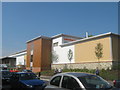
6
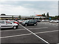
Hythe, Military Road
Hythe, Sainbury's Superstore Car Park, Military Road, CT21 5BH
Image: © Helmut Zozmann
Taken: 12 Jul 2011
0.05 miles
7
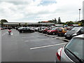
Hythe, Kent
Hythe (Kent), 19 Military Road, Carpark Sainsbury's Supermarket.
Image: © Helmut Zozmann
Taken: 14 Jul 2012
0.05 miles
8

Old Boundary Marker on Military Road, Hythe
War Department Estate Boundary Marker on the northeast side of the T junction of the A259 Military Road and Sir John Moore Avenue. Hythe parish. Probably inscribed below pavement level W D / ↑ / No 1, marking the former boundary of the School of Musketry which was established in Hythe in 1853.
Milestone Society National ID: KE_WDHYTH01em
Image: © P Collins
Taken: 15 Jan 2022
0.05 miles
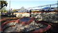
10
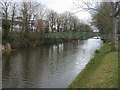
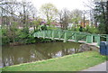
Royal Military Canal
Royal Military Canal with bridge across to Military Road
Image: © Shaun Ferguson
Taken: 31 Mar 2013
0.05 miles