IMAGES TAKEN NEAR TO
Lympne, HYTHE, CT21 4PF
Introduction
This page details the photographs taken nearby to CT21 4PF by members of the Geograph project.
The Geograph project started in 2005 with the aim of publishing, organising and preserving representative images for every square kilometre of Great Britain, Ireland and the Isle of Man.

There are currently over 7.5m images from over14,400 individuals and you can help contribute to the project by visiting https://www.geograph.org.uk
Image Map
Images are licensed for reuse under creativecommons.org/licenses/by-sa/2.0
Notes
- Clicking on the map will re-center to the selected point.
- The higher the marker number, the further away the image location is from the centre of the postcode.
Image Listing (27 Images Found)
Images are licensed for reuse under creativecommons.org/licenses/by-sa/2.0
Image
Details
Distance
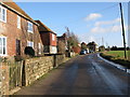
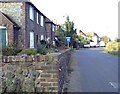
2
Manor Farm Cottages
On the B2067 in Court-at-Street, near Manor Farm.
Image: © David Anstiss
Taken: 19 Sep 2010
0.02 miles
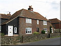
5
Court at Street, near Lympne
'Street' in a placename often indicates a location on a Roman road. This is no exception, the B2067 between Lympne and Aldington is indeed Roman. There used to be a pub in this hamlet called the Welcome Stranger.
Image: © Adam Colton
Taken: 9 Jul 2005
0.05 miles
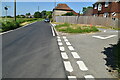
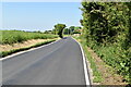
6
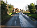
Looking E along the B2067 to Court-At-Street
Image: © Nick Smith
Taken: 17 Jan 2010
0.05 miles
7
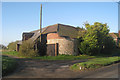
Oast House at Manor Farm, Court-At-Street, Kent
Image: © Oast House Archive
Taken: 8 Apr 2010
0.08 miles
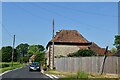
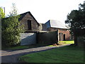
8
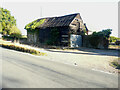
Derelict barn
The barn together with the farmhouse of Image is up for sale.
Image: © John Baker
Taken: 4 Sep 2022
0.08 miles
10
Buildings on Manor Farm, Court-at-Street
Image: © Nick Smith
Taken: 17 Jan 2010
0.09 miles