IMAGES TAKEN NEAR TO
St. Marys Road, HYTHE, CT21 4NU
Introduction
This page details the photographs taken nearby to St. Marys Road, CT21 4NU by members of the Geograph project.
The Geograph project started in 2005 with the aim of publishing, organising and preserving representative images for every square kilometre of Great Britain, Ireland and the Isle of Man.

There are currently over 7.5m images from over14,400 individuals and you can help contribute to the project by visiting https://www.geograph.org.uk
Image Map
Images are licensed for reuse under creativecommons.org/licenses/by-sa/2.0
Notes
- Clicking on the map will re-center to the selected point.
- The higher the marker number, the further away the image location is from the centre of the postcode.
Image Listing (99 Images Found)
Images are licensed for reuse under creativecommons.org/licenses/by-sa/2.0
Image
Details
Distance
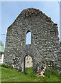
1
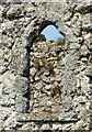
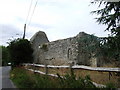
St. Mary's Church, St. Mary's Road, West Hythe
Disused and in ruins, it is a Grade II listed monument monitored by English Heritage. It was constructed in the 12th century and heavily rebuilt in the 14th century.
Image: © pam fray
Taken: 12 May 2016
0.01 miles
2
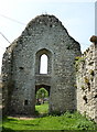
St. Mary's Church, St. Mary's Road, West Hythe
Disused and in ruins, it is a Grade II listed monument monitored by English Heritage. It was constructed in the 12th century and heavily rebuilt in the 14th century.
Image: © pam fray
Taken: 12 May 2016
0.01 miles
3
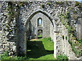
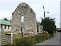
St. Mary's Church, West Hythe
http://www.hereshistorykent.org.uk/DisplayArticle.cfm?placeID=233&categoryID=58&placename=Hythe&source=wn
Ruined church in West Hythe dedicated to St. Mary.
Image: © Chris Heaton
Taken: 1 May 2013
0.01 miles
4
St. Mary's Church, St. Mary's Road, West Hythe
Disused and in ruins, it is a Grade II listed monument monitored by English Heritage. It was constructed in the 12th century and heavily rebuilt in the 14th century.
Image: © pam fray
Taken: 12 May 2016
0.01 miles
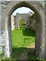
5
St. Mary's Church, St. Mary's Road West Hythe
Disused and in ruins, it is a Grade II listed monument monitored by English Heritage. It was constructed in the 12th century and heavily rebuilt in the 14th century.
Image: © pam fray
Taken: 12 May 2016
0.02 miles