IMAGES TAKEN NEAR TO
Burmarsh Road, HYTHE, CT21 4NH
Introduction
This page details the photographs taken nearby to Burmarsh Road, CT21 4NH by members of the Geograph project.
The Geograph project started in 2005 with the aim of publishing, organising and preserving representative images for every square kilometre of Great Britain, Ireland and the Isle of Man.

There are currently over 7.5m images from over14,400 individuals and you can help contribute to the project by visiting https://www.geograph.org.uk
Image Map
Images are licensed for reuse under creativecommons.org/licenses/by-sa/2.0
Notes
- Clicking on the map will re-center to the selected point.
- The higher the marker number, the further away the image location is from the centre of the postcode.
Image Listing (48 Images Found)
Images are licensed for reuse under creativecommons.org/licenses/by-sa/2.0
Image
Details
Distance
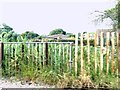
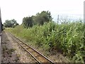
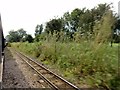
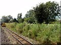
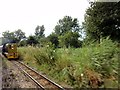
3
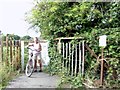
Palmarsh, RH&DR
Palmarsh, RH&DR, footpath level crossing between Heron's Way and Palmbeach Avenue.
Image: © Helmut Zozmann
Taken: 5 Aug 2012
0.09 miles

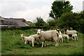
8

Sheep Near Hythe
Seen in a field beside the Romney, Hythe and Dymchurch Railway.
Image: © Peter Trimming
Taken: 11 May 2019
0.13 miles
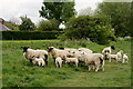
9
Sheep Near Hythe
Seen in a field beside the Romney, Hythe and Dymchurch Railway.
Image: © Peter Trimming
Taken: 11 May 2019
0.13 miles
10
Sheep Near Hythe
Seen in a field beside the Romney, Hythe and Dymchurch Railway.
Image: © Peter Trimming
Taken: 11 May 2019
0.13 miles