IMAGES TAKEN NEAR TO
Dymchurch Road, HYTHE, CT21 4NF
Introduction
This page details the photographs taken nearby to Dymchurch Road, CT21 4NF by members of the Geograph project.
The Geograph project started in 2005 with the aim of publishing, organising and preserving representative images for every square kilometre of Great Britain, Ireland and the Isle of Man.

There are currently over 7.5m images from over14,400 individuals and you can help contribute to the project by visiting https://www.geograph.org.uk
Image Map
Images are licensed for reuse under creativecommons.org/licenses/by-sa/2.0
Notes
- Clicking on the map will re-center to the selected point.
- The higher the marker number, the further away the image location is from the centre of the postcode.
Image Listing (30 Images Found)
Images are licensed for reuse under creativecommons.org/licenses/by-sa/2.0
Image
Details
Distance
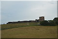
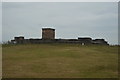
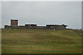
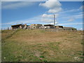
4
Dymchurch Redoubt
A fortress built during the Napoleonic wars to support the neighbouring Martello towers. Completed in 1812 by which time the threat was over. See http://en.wikipedia.org/wiki/Dymchurch_Redoubt
Image: © Bikeboy
Taken: 24 Jul 2013
0.11 miles
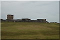
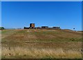
10

View of the Dymchurch Redoubt on Dymchurch Road from the Romney, Hythe & Dymchurch Railway
Looking south-southeast.
Image: © Robert Lamb
Taken: 4 Sep 2016
0.11 miles