IMAGES TAKEN NEAR TO
Stone Street, HYTHE, CT21 4HT
Introduction
This page details the photographs taken nearby to Stone Street, CT21 4HT by members of the Geograph project.
The Geograph project started in 2005 with the aim of publishing, organising and preserving representative images for every square kilometre of Great Britain, Ireland and the Isle of Man.

There are currently over 7.5m images from over14,400 individuals and you can help contribute to the project by visiting https://www.geograph.org.uk
Image Map
Images are licensed for reuse under creativecommons.org/licenses/by-sa/2.0
Notes
- Clicking on the map will re-center to the selected point.
- The higher the marker number, the further away the image location is from the centre of the postcode.
Image Listing (67 Images Found)
Images are licensed for reuse under creativecommons.org/licenses/by-sa/2.0
Image
Details
Distance
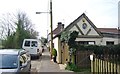
5
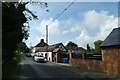
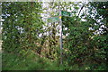
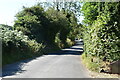
Westenhanger Village
Looking along Stone Street on the north side of Westenhanger.
Image: © DS Pugh
Taken: 3 Sep 2022
0.04 miles
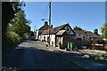
6
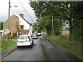
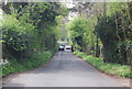
Stone Street in Westenhanger
This ancient Roman road leads from the A20 Ashford Road and A261 Hythe Road junction, through the small village along the road. The road also leads towards Folkestone Racecourse and Westenhanger Railway Station. At the station, the road ends due to the High Speed Railway and the M20 Motorway. The route survives as a footbridge connecting to the Sellindge section of Stone Street.
Image: © David Anstiss
Taken: 17 Oct 2010
0.04 miles