IMAGES TAKEN NEAR TO
Sandling Road, HYTHE, CT21 4ES
Introduction
This page details the photographs taken nearby to Sandling Road, CT21 4ES by members of the Geograph project.
The Geograph project started in 2005 with the aim of publishing, organising and preserving representative images for every square kilometre of Great Britain, Ireland and the Isle of Man.

There are currently over 7.5m images from over14,400 individuals and you can help contribute to the project by visiting https://www.geograph.org.uk
Image Map
Images are licensed for reuse under creativecommons.org/licenses/by-sa/2.0
Notes
- Clicking on the map will re-center to the selected point.
- The higher the marker number, the further away the image location is from the centre of the postcode.
Image Listing (7 Images Found)
Images are licensed for reuse under creativecommons.org/licenses/by-sa/2.0
Image
Details
Distance
1
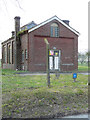
Pumping station
A building containing machinery for pumping large amounts of water.
Image: © John Baker
Taken: 14 Apr 2019
0.06 miles
2
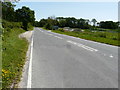
Ashford Road (A20)
Almost opposite the lay-by, there is a Image
Image: © John Baker
Taken: 3 Jun 2019
0.11 miles
3

Byway at Postling Wents
Bartholomew's Wood to the left is an ancient woodland which is designated a Site of Nature Conservation Interest.
Image: © Carol Rose
Taken: 2 Jun 2007
0.11 miles
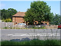
5
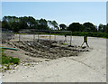
Development site, Ashford Road
I have been unable to discover why the land has been cleared.
Image: © John Baker
Taken: 3 Jun 2019
0.12 miles
6
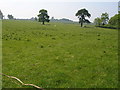
Sheep graze in a designated Area of Outstanding Natural Beauty
Image: © Carol Rose
Taken: 2 Jun 2007
0.21 miles
7
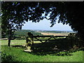
View from bottom of Tolsford hill looking West
A short ride on a summer's day.
Image: © John Nash
Taken: 8 Aug 2005
0.22 miles