IMAGES TAKEN NEAR TO
Maycock Place, CT21 4EQ
Introduction
This page details the photographs taken nearby to Maycock Place, CT21 4EQ by members of the Geograph project.
The Geograph project started in 2005 with the aim of publishing, organising and preserving representative images for every square kilometre of Great Britain, Ireland and the Isle of Man.

There are currently over 7.5m images from over14,400 individuals and you can help contribute to the project by visiting https://www.geograph.org.uk
Image Map
Images are licensed for reuse under creativecommons.org/licenses/by-sa/2.0
Notes
- Clicking on the map will re-center to the selected point.
- The higher the marker number, the further away the image location is from the centre of the postcode.
Image Listing (86 Images Found)
Images are licensed for reuse under creativecommons.org/licenses/by-sa/2.0
Image
Details
Distance
1
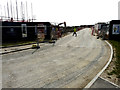
Nickolls Road
The road is part of the Martello Lakes development.
Planning permission has been approved, with conditions, by Folkestone and Hythe District Council under application number Y06/1079/SH for “outline application for mixed use development comprising (1050 dwellings); employment development (use class B1, 15,000 sq m); local centre (500 sq. metres use classes A1/A2, 500 sq metres use classes A3/A4/A5); community centre/community facilities (1,000 sq metres use class D1); public open space (8.5 hectares); structural open space (10.3 hectares); retention and alteration of water bodies (retained area 15.5 hectares); provision of two new access points to Dymchurch Road; and site restoration including raising of land levels”.
Image: © John Baker
Taken: 1 Apr 2019
0.02 miles
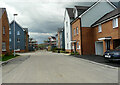
2
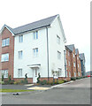
Maycock Place
Part of the Martello Towers development; a similar view of Image was taken in February 2023.
Image: © John Baker
Taken: 19 Nov 2023
0.02 miles
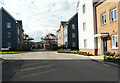
3
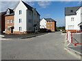
Bennett Close
The road has a junction with Image and is part of the Martello Towers development.
Image: © John Baker
Taken: 27 Aug 2023
0.03 miles
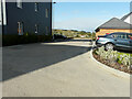
4
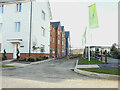
Unnamed road
Part of the Martello Towers development.
Image: © John Baker
Taken: 19 Feb 2023
0.03 miles
5

Rolfe Way
Part of the Martello Towers development.
Image: © John Baker
Taken: 6 Aug 2023
0.03 miles
6
Rolfe Way
Part of the Martello Towers development.
Image: © John Baker
Taken: 6 Aug 2023
0.03 miles
7
Hayles Walk
Part of the Martello Towers development.
Image: © John Baker
Taken: 27 Aug 2023
0.04 miles
8
Rolfe Way
A similar view of Image was taken in the first week of August 2023; the road is part of the Martello Towers development.
Image: © John Baker
Taken: 27 Aug 2023
0.04 miles
9

Wilkinson Drive
Part of the Martello Towers development.
Image: © John Baker
Taken: 6 Aug 2023
0.04 miles
10
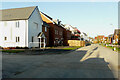
Nicholls Road
The road is part of the Martello Lakes development and this was Image in September 2022; this view was taken beyond the hoarding and shows the houses that have been built or are under construction.
Image: © John Baker
Taken: 9 Nov 2022
0.04 miles