IMAGES TAKEN NEAR TO
Orchard Valley, HYTHE, CT21 4EA
Introduction
This page details the photographs taken nearby to Orchard Valley, CT21 4EA by members of the Geograph project.
The Geograph project started in 2005 with the aim of publishing, organising and preserving representative images for every square kilometre of Great Britain, Ireland and the Isle of Man.

There are currently over 7.5m images from over14,400 individuals and you can help contribute to the project by visiting https://www.geograph.org.uk
Image Map
Images are licensed for reuse under creativecommons.org/licenses/by-sa/2.0
Notes
- Clicking on the map will re-center to the selected point.
- The higher the marker number, the further away the image location is from the centre of the postcode.
Image Listing (387 Images Found)
Images are licensed for reuse under creativecommons.org/licenses/by-sa/2.0
Image
Details
Distance
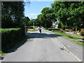
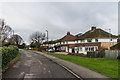
2
Orchard Valley
1930s(?) housing north of the Royal Military Canal.
Image: © Ian Capper
Taken: 14 Jan 2017
0.03 miles
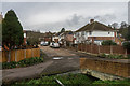
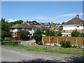
5
Green Lane
1930s(?) housing north of the Royal Military Canal.
Image: © Ian Capper
Taken: 14 Jan 2017
0.05 miles

8
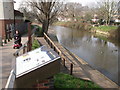
Royal Military Canal, with mobility scooter, Hythe
Image: © nick macneill
Taken: 4 Mar 2011
0.06 miles
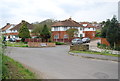
9
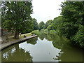
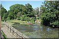
Royal Military Canal, Hythe
West of Scanlons Bridge.
Image: © Robin Webster
Taken: 13 Jul 2013
0.06 miles
10
Weed Removal on the Canal
A small dredger scooping up a thick coating of duckweed on the Royal Military Canal by Scanlons Bridge.
Image: © Des Blenkinsopp
Taken: 16 Jun 2021
0.06 miles