IMAGES TAKEN NEAR TO
Lake Drive, HYTHE, CT21 4BN
Introduction
This page details the photographs taken nearby to Lake Drive, CT21 4BN by members of the Geograph project.
The Geograph project started in 2005 with the aim of publishing, organising and preserving representative images for every square kilometre of Great Britain, Ireland and the Isle of Man.

There are currently over 7.5m images from over14,400 individuals and you can help contribute to the project by visiting https://www.geograph.org.uk
Image Map
Images are licensed for reuse under creativecommons.org/licenses/by-sa/2.0
Notes
- Clicking on the map will re-center to the selected point.
- The higher the marker number, the further away the image location is from the centre of the postcode.
Image Listing (74 Images Found)
Images are licensed for reuse under creativecommons.org/licenses/by-sa/2.0
Image
Details
Distance
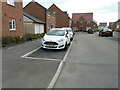
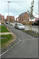
1
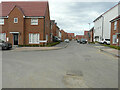
Lake Drive
Planning permission has been approved, with conditions, by Folkestone and Hythe District Council under application number Y06/1079/SH for “outline application for mixed use development comprising (1050 dwellings); employment development (use class B1, 15,000 sq m); local centre (500 sq. metres use classes A1/A2, 500 sq metres use classes A3/A4/A5); community centre/community facilities (1,000 sq metres use class D1); public open space (8.5 hectares); structural open space (10.3 hectares); retention and alteration of water bodies (retained area 15.5 hectares); provision of two new access points to Dymchurch Road; and site restoration including raising of land levels”.
The road is part of the Martello Lakes development.
Image: © John Baker
Taken: 6 Sep 2020
0.01 miles
2
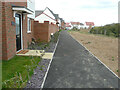
Woodpecker Way
Planning permission has been approved, with conditions, by Folkestone and Hythe District Council under application number Y06/1079/SH for “outline application for mixed use development comprising (1050 dwellings); employment development (use class B1, 15,000 sq m); local centre (500 sq. metres use classes A1/A2, 500 sq metres use classes A3/A4/A5); community centre/community facilities (1,000 sq metres use class D1); public open space (8.5 hectares); structural open space (10.3 hectares); retention and alteration of water bodies (retained area 15.5 hectares); provision of two new access points to Dymchurch Road; and site restoration including raising of land levels”.
The path is part of the Martello Lakes development.
Image: © John Baker
Taken: 6 Sep 2020
0.01 miles
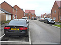
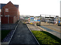
3
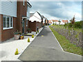
Woodpecker Way
Planning permission has been approved, with conditions, by Folkestone and Hythe District Council under application number Y06/1079/SH for “outline application for mixed use development comprising (1050 dwellings); employment development (use class B1, 15,000 sq m); local centre (500 sq. metres use classes A1/A2, 500 sq metres use classes A3/A4/A5); community centre/community facilities (1,000 sq metres use class D1); public open space (8.5 hectares); structural open space (10.3 hectares); retention and alteration of water bodies (retained area 15.5 hectares); provision of two new access points to Dymchurch Road; and site restoration including raising of land levels”.
The path is part of the Martello Lakes development and is a continuation of this section of Image The same section of Image before the verges either side of the path were landscaped.
Image: © John Baker
Taken: 20 Jun 2021
0.03 miles
4
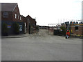
Lake Drive
The Martello Lakes development is being extended, which necessitates the construction of new roads and the entrance to this road is opposite Image This was Image in August 2019.
Planning permission has been approved, with conditions, by Folkestone and Hythe District Council under application number Y06/1079/SH for “outline application for mixed use development comprising (1050 dwellings); employment development (use class B1, 15,000 sq m); local centre (500 sq. metres use classes A1/A2, 500 sq metres use classes A3/A4/A5); community centre/community facilities (1,000 sq metres use class D1); public open space (8.5 hectares); structural open space (10.3 hectares); retention and alteration of water bodies (retained area 15.5 hectares); provision of two new access points to Dymchurch Road; and site restoration including raising of land levels”.
Image: © John Baker
Taken: 1 Apr 2019
0.03 miles
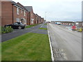
5
Lake Drive
Planning permission has been approved, with conditions, by Folkestone and Hythe District Council under application number Y06/1079/SH for “outline application for mixed use development comprising (1050 dwellings); employment development (use class B1, 15,000 sq m); local centre (500 sq. metres use classes A1/A2, 500 sq metres use classes A3/A4/A5); community centre/community facilities (1,000 sq metres use class D1); public open space (8.5 hectares); structural open space (10.3 hectares); retention and alteration of water bodies (retained area 15.5 hectares); provision of two new access points to Dymchurch Road; and site restoration including raising of land levels”.
The road is part of the Martello Lakes development. and this was Image in January 2020.
Image: © John Baker
Taken: 6 Sep 2020
0.03 miles
6
Lake Drive
Planning permission has been approved, with conditions, by Folkestone and Hythe District Council under application number Y06/1079/SH for “outline application for mixed use development comprising (1050 dwellings); employment development (use class B1, 15,000 sq m); local centre (500 sq. metres use classes A1/A2, 500 sq metres use classes A3/A4/A5); community centre/community facilities (1,000 sq metres use class D1); public open space (8.5 hectares); structural open space (10.3 hectares); retention and alteration of water bodies (retained area 15.5 hectares); provision of two new access points to Dymchurch Road; and site restoration including raising of land levels”.
The road is part of the Martello Lakes development and this was Image in August 2019.
Image: © John Baker
Taken: 24 Nov 2019
0.03 miles
7
Lake Drive
Planning permission has been approved, with conditions, by Folkestone and Hythe District Council under application number Y06/1079/SH for “outline application for mixed use development comprising (1050 dwellings); employment development (use class B1, 15,000 sq m); local centre (500 sq. metres use classes A1/A2, 500 sq metres use classes A3/A4/A5); community centre/community facilities (1,000 sq metres use class D1); public open space (8.5 hectares); structural open space (10.3 hectares); retention and alteration of water bodies (retained area 15.5 hectares); provision of two new access points to Dymchurch Road; and site restoration including raising of land levels”.
The road is part of the Martello Lakes development and this was Image in November 2019.
Image: © John Baker
Taken: 12 Jan 2020
0.04 miles
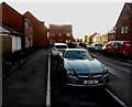
8
Nickolls Road
Planning permission has been approved, with conditions, by Folkestone and Hythe District Council under application number Y06/1079/SH for “outline application for mixed use development comprising (1050 dwellings); employment development (use class B1, 15,000 sq m); local centre (500 sq. metres use classes A1/A2, 500 sq metres use classes A3/A4/A5); community centre/community facilities (1,000 sq metres use class D1); public open space (8.5 hectares); structural open space (10.3 hectares); retention and alteration of water bodies (retained area 15.5 hectares); provision of two new access points to Dymchurch Road; and site restoration including raising of land levels”.
This was Image in April 2019; the road is part of the Martello Lakes development.
Image: © John Baker
Taken: 24 Nov 2019
0.04 miles
9
Brimstone Way
Planning permission has been approved, with conditions, by Folkestone and Hythe District Council under application number Y06/1079/SH for “outline application for mixed use development comprising (1050 dwellings); employment development (use class B1, 15,000 sq m); local centre (500 sq. metres use classes A1/A2, 500 sq metres use classes A3/A4/A5); community centre/community facilities (1,000 sq metres use class D1); public open space (8.5 hectares); structural open space (10.3 hectares); retention and alteration of water bodies (retained area 15.5 hectares); provision of two new access points to Dymchurch Road; and site restoration including raising of land levels”.
The road is part of the Martello Lakes development.
Image: © John Baker
Taken: 6 Sep 2020
0.04 miles
10
Nickolls Road
Planning permission has been approved, with conditions, by Folkestone and Hythe District Council under application number Y06/1079/SH for “outline application for mixed use development comprising (1050 dwellings); employment development (use class B1, 15,000 sq m); local centre (500 sq. metres use classes A1/A2, 500 sq metres use classes A3/A4/A5); community centre/community facilities (1,000 sq metres use class D1); public open space (8.5 hectares); structural open space (10.3 hectares); retention and alteration of water bodies (retained area 15.5 hectares); provision of two new access points to Dymchurch Road; and site restoration including raising of land levels”.
The house on the left, is the same at that at the far end of this part of Image; the road is part of the Martello Lakes development.
Image: © John Baker
Taken: 12 Jan 2020
0.04 miles