IMAGES TAKEN NEAR TO
Fairlight Road, HYTHE, CT21 4AD
Introduction
This page details the photographs taken nearby to Fairlight Road, CT21 4AD by members of the Geograph project.
The Geograph project started in 2005 with the aim of publishing, organising and preserving representative images for every square kilometre of Great Britain, Ireland and the Isle of Man.

There are currently over 7.5m images from over14,400 individuals and you can help contribute to the project by visiting https://www.geograph.org.uk
Image Map
Images are licensed for reuse under creativecommons.org/licenses/by-sa/2.0
Notes
- Clicking on the map will re-center to the selected point.
- The higher the marker number, the further away the image location is from the centre of the postcode.
Image Listing (7 Images Found)
Images are licensed for reuse under creativecommons.org/licenses/by-sa/2.0
Image
Details
Distance
1
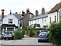
24, Seaton Avenue
Planning permission has been granted, with conditions, by Folkestone and Hythe District Council under application number 22/1684/FH for the "erection of front and rear extensions at ground and first floor and conversion of garage to living accommodation".
Taken during a photographic outing on New Year's Day afternoon.
Image: © John Baker
Taken: 1 Jan 2023
0.16 miles
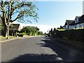
2
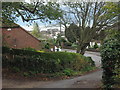
Brockhill Road, Hythe
Heading towards North Road.
In the background, is a roofscape over Hythe.
Image: © David Anstiss
Taken: 13 Nov 2010
0.17 miles
3
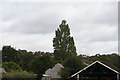
View of houses on the hill from Hythe station on the Romney, Hythe & Dymchurch Railway
Looking north-northeast.
Image: © Robert Lamb
Taken: 4 Sep 2016
0.19 miles
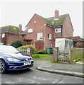
4
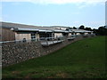
St Augustine's Catholic Primary School, Saltwood
This school has won architectural awards.
Image: © Roger Miller
Taken: 10 Aug 2005
0.20 miles
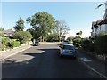
5
Saltwood - 2015
Saltwood, Kent, Brockhill Road
Image: © Helmut Zozmann
Taken: 8 Aug 2015
0.22 miles
6
Saltwood - 2015
Saltwood, Kent, Brockhill Road
Image: © Helmut Zozmann
Taken: 8 Aug 2015
0.23 miles