IMAGES TAKEN NEAR TO
Hawe Lane, CANTERBURY, CT2 0LP
Introduction
This page details the photographs taken nearby to Hawe Lane, CT2 0LP by members of the Geograph project.
The Geograph project started in 2005 with the aim of publishing, organising and preserving representative images for every square kilometre of Great Britain, Ireland and the Isle of Man.

There are currently over 7.5m images from over14,400 individuals and you can help contribute to the project by visiting https://www.geograph.org.uk
Image Map
Images are licensed for reuse under creativecommons.org/licenses/by-sa/2.0
Notes
- Clicking on the map will re-center to the selected point.
- The higher the marker number, the further away the image location is from the centre of the postcode.
Image Listing (13 Images Found)
Images are licensed for reuse under creativecommons.org/licenses/by-sa/2.0
Image
Details
Distance
2
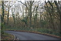
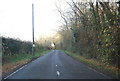
Sharp bend, Hawe Lane
Going through Hoades Wood.
Image: © N Chadwick
Taken: 10 Dec 2011
0.05 miles
3
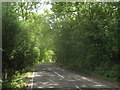
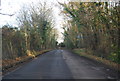
Hawe Lane beside Hoades Wood
This lane leads from Popes Lane towards the A28 Staines Hill.
Hoades Wood is on the right.
Image: © David Anstiss
Taken: 11 Jul 2010
0.07 miles
4
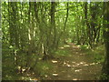
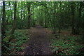
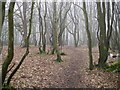
Footpath in Hoades Wood
This unofficial path leads parallel beside Hawe Lane towards Babs Oak Hill.
Image: © David Anstiss
Taken: 11 Jul 2010
0.09 miles
6
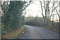
Footpath in Hoades Wood
There is no pavement by Hawe Lane but this path provides a suitable alternative.
Image: © Bill Boaden
Taken: 28 Jun 2012
0.14 miles
10
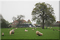
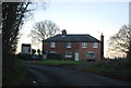
The Oast House, Hawe Lane, Sturry, Kent
Single round kiln oast house.
Image: © Oast House Archive
Taken: 17 Apr 2009
0.17 miles